Sunday

Friends of Cave Creek Canyon Garden Party

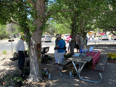
The finished garden at the Cave Creek Canyon visitors center was the center of attention at a garden party hosted by FOCCC to celebrate the newly completed garden.  A number of local individuals and groups set up informational tables around the front of the Cave Creek Canyon visitors center with interactive displays covering astronomy, native plants and animals, and the prehistoric residents, while food was served behind the visitors center.  Native plant sales took place out in the new garden area, and of course the visitors center was open for inspection.  The new flag purchased by FOCCC is now installed on the signage erected last year alerting new visitors to the visitors center.

FOCCC garden party
panorama of garden party

visitors to FOCCC garden party
visitors at FOCCC garden party 

friends of cave creek canyon plant sales
Native plants at the Friends of Cave Creek Canyon's garden party
Coronado National Forest visitors center in chiricahua mountains
Interior of the visitors center in Cave Creek Canyon

Friday

Cultural Resource Inventory V: A Mimbres Post Classic Hamlet

The earliest evidence of habitation found on the the Painted Pony Ranch and Resort is a small 30 room presumptive Mimbres hamlet.  At first glance the site appears nothing more than a mass of rocks (photograph 1) but closer examination revealed several stone room outlines with 2 different orientations (photograph 2).  The possibility of a habitation site along the San Simon River was reinforced by an examination of water flow patterns along the riverbed as seen on Google Earth (photograph 3).  Water from the San Simon and the Chiricahua mountains (Horseshoe canyon, Sulphur Canyon, and Cave Creek Canyon) met just upstream of the current location of the hamlet.  This would have ensured a water supply for agricultural activities along this segment of the San Simon River.  A simple survey, using GPS, was initiated on the site locating evidence of room corners and identifying room block outlines (photograph 4).  The room outlines were in 2 distinct orientations.  Three rooms (yellow) were orientated at about 50 degrees while the more numerous room blocks (red) were orientated almost due north.  This is consistent with the reorganization phase of the Mimbres culture after 1150 CE where field houses (yellow rooms) were enlarged and new buildings erected (red room blocks) as the Mimbres moved out of the large villages and dispersed across the landscape.

A number of circular rock features were also observed on the site and when mapped these circular rock features appeared to delineate another room block (photographs 3 and 5).  Mimbres structures were stone whereas other cultural groups relied on adobe as a building material.  A room block with only corners of stone suggest a transition in local building styles in the post classic period in the San Simon Valley.  Either due to possible decreased labor costs in adobe walled buildings or a local adaptation to building techniques used by other cultural groups (perhaps Hohokam) during the reorganization phase.

In addition to presumptive room blocks, 2 clay pits were identified next to the hamlet where material for walls and pottery was mined.  Two digging tools were found in association with these clay pits, both large modified flakes which would allow easy removal of clay used in siding stone walls (photograph 6).

Although no diagnostic pottery was recovered from a surface search, shell, scrapers, and flaking cores were recovered.  The lack of ceramics suggests this site was either a short term occupation or was occupied by a group with little material goods.

Panorama of hamlet. The small rise denotes the hamlet location.

Room outline approximately 15' x 18'.  The yucca may mark the location of the rooms center post.

Drainage patterns upstream of hamlet.

GPS locations showing room block outlines and other features.
mimbres hamlet wall feature
Circular rock feature forming part of a room block outline.
mimbres clay pit
Clay pit with in situ digging tool.

Thursday

Cultural Resource Inventory IV

Evidence of prehistoric occupation around the Painted Pony Resort is widespread.  Evidence of Mogollon (including Mimbres), Hohokam, Casas Grande, and possibly Trincheras cultures may be found throughout the San Simon valley.  This intersection of cultural influences in the valley is reflected today in the native (Pima to the west, Zuni and Apache to the north), hispanic, and anglo cultures who now occupy the boot heel of New Mexico and southern Arizona.  As an intersection of cultural groups through time the San Simon valley offers insights into cultural interactions not found in areas with a single predominant cultural group and thus offers unique perspective on prehistoric cultural interactions.  While the Dynamics of Southwest Prehistory is a recent attempt to integrate information about prehistoric cultures of the southwest into an overall conceptual framework, the more localized approach such as the Malpi Borderlands is more appropriate for those trying to understand land use and occupation through time along the San Simon valley.

An example of documented land use in the San Simon valley, the graph below shows the distribution of pottery types on a large ruin in the San Simon valley versus time.  Found along a north/south route through the valley, this ruin was part of a network of sites occupied in the past.  Using a simplified contextual seriation technique allows the occupation to be dated from 1200 to 1350, a span of about 150 years which is consistent with ground stone wear patterns on metates found on the site.  Beginning at the end of the Mimbres reorganization, or after, this Animas phase site demonstrates the cultural influence from from a number of surrounding groups as demonstrated by differing pottery types.

Although little painted pottery is found on the 320 acres of the Painted Pony Ranch (Gila black on white was documented from the property), the distribution of an abundance of stone tools found on the property suggest a number of small occupation sites existed during this late prehistoric period.


pottery types from a San Simon valley prehistoric ruin
Cultural resource inventory III
Cultural resource inventory II
Cultural resource inventory I

Sunday

A Quote about Blogging

Creating interesting blog posts often combines visual images with words, but blogging is fundamentally about the written word and while images are important in creating a feeling or adding to the story, the ability to manipulate the written word is crucial to engaging readers. Some days though no matter how hard one writes, rewrites, and edits, the words just do not seem to order themselves in a way that captures the authors intent. On those days I remind myself that language is our common currency but some days my wallet is empty and move on.

Thursday

A Potential Meal or a Story of Life in New Mexico

The expansion of the Painted Pony Resort to include an additional 216 acres of San Simon Riverbed outside the isolated twin hamlets of Portal and Rodeo in southern Arizona and New Mexico meant fencing.  Not a particularly attractive proposition but cattle love good grasslands and a herd of 40 or so had moved into the area, grazing on the tall native grasses of the river bottom.  To protect the existing native grasses and allow re-growth of over grazed areas the owner had decided to fence the land and my job was to make it happen.  Fortunately only a mile and half of fence was required to completely enclose the newly acquired property since existing fence was in place on north and east sides so it was time to get busy.  Throughout December and January the daily sound of hammering t-posts was heard across the San Simon Valley as new t-posts and then barbwire was installed.  It was a busy time and although new at fencing, a rhythm was quickly established along the flat terrain allowing rapid progress, but the far side of the riverbed was another matter.  A steep bank rose from the riverbed which was cut by several deep arroyos, presenting a problem.  Driving t-posts into rocky ground along the bench above the riverbed proved to be a much slower task but stringing barbwire across arroyos proved even more challenging.   When strung, the wire was upwards of 20 feet above the bottom of each arroyo and just the right amount of tension was required to allow each of the 4 strands to be pulled down to the awaiting t-posts along the bottom of the arroyo and clipped in place.  To little tension and the fence line would sag and not do its‘ job keeping the cattle at bay, to much tension and it was impossible to pull each strand down and clip it to the t-posts.  The process of adjusting tension and pulling down wire was repeated with each strand of barbwire as work slowly progressed through the rocky arroyos. 

One afternoon while stretching wire along the bottom of one arroyo a particularly memorable event occurred.  After adjusting the tension on a strand of new barbwire crossing an arroyo the process of pulling the wire down to attach it to t-posts began.  Having misjudged the amount of tension required the wire would not reach its’ place on the t-post.  It was just a few inches short of its intended position but no matter how it was pulled the wire would not quite reach.  The prospect of hiking back to the end post and loosening the wire again was not particularly appealing late in the afternoon after a full day of fencing, so dropping one glove to get a better grip on the wire and putting my full weight on the wire one more attempt was made to get the barbwire to its intended location on the t-post and clipped in place.   It was at that moment the barbwire broke pulling through my ungloved hand.  As the barbwire suddenly parted several barbs raked through my closed ungloved palm that was gripping the wire.  That sinking feeling one gets when things go wrong immediately started to set in and the sight of blood only compounded the situation.  More in shock and angered at a preventable mistake I cursed.  I cursed the wire, the fence, and myself for the error.  Opening the injured hand there seemed less damage than expected.  Although there was blood, it was dripping and not spurting so shaking off the excess and pulling the glove back on it was back to work. 

A slight breeze from the north had made working conditions pleasant throughout the day and figuring only about an hour of good light left it was back to clipping the bottom unbroken wire to t-posts along the bench top.  Repair of the broken strand of barbwire would be put off till another day.  After climbing back out of the arroyo and working from t-post to t-post the bottom strand of wire was clipped in place which required kneeing down and pulling the wire up from the ground to install the clip.  After about 20 minutes of clipping wire across the bench top and upon arising from the ground while simultaneously turning around I found myself face to face with a well fed young coyote.  With a shiny coat this coyote did not appear spooked by my presence but rather he seemed to be sizing me up as a potential meal.  The sudden realization hit that I had been bleeding, was upwind of this coyote, and had been down on the ground not moving but clipping wire.  The smell of fresh blood indicated a meal and the coyote had come to investigate a potential stroke of  good luck.  We stared at one another for perhaps 30 seconds or so, neither of us moving, just staring.  Deciding to speak to this unexpected visitor, I first let him know I did not consider myself a coyote meal, then secondly apologizing for having nothing for him to eat.  Moving on to the weather I commented on the pleasant day for working outside while the coyote, not taking his eyes off me, explored a small mesquite that stood between us.  After several minutes of staring, the coyote seemed to realize that his potential good luck was actually bad luck, not a meal, and he slowly turned and quite casually began to saunter away.  I watched the coyote for about another 5 minutes as he descended back into the San Simon riverbed, crossing it heading towards some cattle but never looking back at his misfortune and lost meal opportunity. 

fence line across the San Simon River
Across the riverbed

fenceline onto river bank
Up the river bank

painted pony resort fence
Down in an arroyo

Monday

Cultural Resource Inventory III

Prior to the 1917 topographic map of area, the San Simon Valley was utilized primarily for cattle.  The best known operator in the area was the San Simon Canal and Cattle company, although other ranches grazed cattle throughout the valley.  Established in 1885 and surviving until 1920 the San Simon Canal and Cattle company was founded by James Harrison Parramore and Claiborne Walker Merchant.  While the open grasslands were inviting to ranchers, water was always an issue.  The approach utilized by the San Simon Cattle company was to gain control of local water resources while ignoring the open grasslands.  Since open range was the rule, this approach allowed the cattle company to use forage on the public domain while not incurring any liability for the land upon which its' cattle grazed.  While maximizing investment return the long term consequences for the landscape were negative but this approach allowed them to stock between 20,000 and 30,000 head of cattle in the valley during this period.

The time frame between the establishment of corporate ranches and the Gadsden Purchase the Chiricahua Apache were the predominant group living on the landscape.  This period is may be best characterized as one of conflict between the US government and those indigenous peoples living on in the area.  The end of this period of conflict was in 1886 with the surrender of Geronimo at the mouth of Skeleton Canyon

Evidence of the Chiricahua Apache may still be found on the landscape, although no evidence of occupation has been found on the Painted Pony Resort, a granary of sticks and mud enclosing a small shelter cave exists on the east side of the Chiricahua mountains near a narrow canyon with other evidence of occupation which likely dates from this period.

As Spain, then Mexico, and then the United States claimed the area maps were produced by each party claiming the area and were used in treaty negotiations.  A number of these maps were compiled into a video as part of the inventory showing the relationships between current landmarks and the landscape as visualized by the mapmakers of the time spanning the period from the late 1700's to the first territorial map produced in 1857.

Cultural resource inventory II
Cultural resource inventory I