 |
| Rustic cabin exterior |

Click photograph to view large formatted image
Showing posts with label Painted Pony Ranch and Resort. Show all posts
Showing posts with label Painted Pony Ranch and Resort. Show all posts
Thursday
Rustic cabin at the Painted Pony Resort
Work continues on the exterior of the newly remodeled 3 bedroom Rustic cabin at the Painted Pony Resort. Work has centered on the exterior of the cabin and low rock wall dividers were built to create a "front yard" to define the front of the cabin. Crusher fines were then laid down to provide a smooth walking surface within this area. All the rock was hauled from around the property and comes from earlier inhabitants previous work. The majority of rock was from a single room in the hamlet across the riverbed and additional rock was hauled from an early homestead on the property. There is no shortage of rock in the alluvial San Simon valley and native rock was used frequently for buildings and walls in the area. A drive into Portal or Rodeo and rock walls and buildings are easily found indicating that native rock has a long history of use as a local building material. Cattle excluding walk through gates are planned in the fence lines allowing those staying in the cabin easy walking access to the main estate for family reunions, weddings, or other events when the cabin is in use.
Monday
Paleontology at the Painted Pony Resort: A Fossil Horse
It was just another morning out on the landscape. This particular morning was spent repairing the one rock check dams along Painted Pony Road after the recent monsoon season. The one rock check dams are small single rows of rocks placed at intervals across a drainage to prevent enlargement and to trap sediment allowing grasses a place to root. This has the added benefit of protecting the road and preventing washouts during heavy rains. So while awaiting the arrival of some prospective clients who were coming by to view the Painted Pony Resort as a location for a planned workshop, check dam maintenance along the road seemed like an easy job. Stopping at each check dam in turn and adding rocks was going smoothly when I noticed an oddly shaped rock in one drainage. Walking over I picked it up and noticed immediately is was not just a rock but rather fossilized teeth in a partial matrix of rock. Noting the location it was back to check dam maintenance. After finishing the maintenance chores and after the prospective clients left, it was back to look for more fossilized teeth. After finding several more examples and a partial rib, all within a 10 ft radius, it was back to the estate for identifications. After stabilizing the finds, which were in generally poor condition, a detailed examination and comparison to identified specimens suggests the fossilized teeth are from a horse (Equus sp. possibly E. scotti or E. mexicanus). The rock matrix surrounding the teeth and rib fragment are indicators that the animal was not a member of the re-introduced modern horses that arrived with the Europeans but rather something older. Horses originally evolved in North America but became extinct in the western hemisphere about 12,000 years ago. In addition, horse bones have been found in multiple Clovis sites including the southwest (1, 2, 3) and human hunting pressure leading to the demise of the horse as a species in North America cannot be ruled out (4).
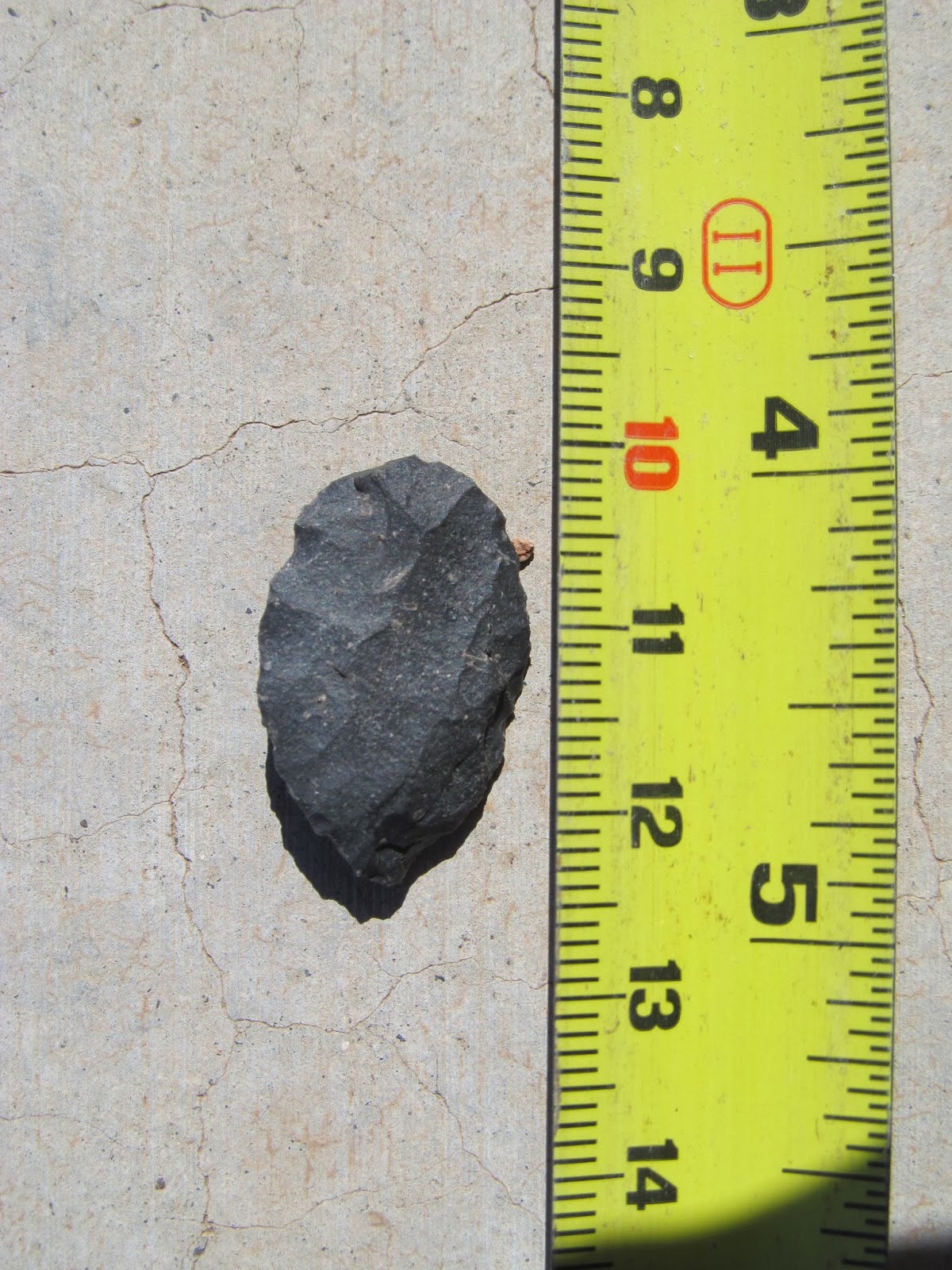
During the second walk of the area, a projectile point turned up within 10 feet (3 m) of the first tooth find at the same elevation. A small leaf shaped bifacial projectile point measuring 25 x 16 x 3 mm, it was clearly different from other projectile points previously found in the area but clearly to small to have brought down an animal with teeth several inches long. A search of Overstreet's typology database turned up a single similarly designed point, a cottonwood leaf found from Arizona to Nevada and California dating from 700-400 B.P. suggesting a spurious association. With the denuded grasslands in the area combined with yearly monsoons spurious associations are always a possibility as material washes out and is transported by the rains. As a test, an area of 10,000 square feet was carefully walked looking for other artifacts, see image below. If the leaf shaped point was associated with the animal teeth then there should be no other artifacts close. If on the other hand the leaf shaped projectile point was not associated with the teeth and the association was the result of chance there should be other artifacts close. Nothing was found west of the road (up dip), while a single small red rhyolite bifacial scraper was found about 70 feet to the northeast (and down dip). To the south 2 partial manos and a metate fragment were found about 80 feet from the teeth and about 50 ft apart. While to the east a large crude chert unifacial scraper was found downstream of the teeth about 40 ft away. Finally, a used chert flaking core was discovered 125 ft slightly southeast of the teeth. Since the dip is to the east all exposed artifacts tend to be downstream of their original deposition sites and the lighter the material the further it will have moved over time if exposed. Based on these observations, it suggests the leaf shaped bifacial point and teeth are associated and the find is not a spurious association. Yet the question remains why such a small unusually shaped projectile point? Conflicting evidence and questions as yet unanswered, it will have to remain a mystery until further material comes to light.
Addendum: Examples of other leaf shaped projectile points from New Mexico may be found here.
 |
| Fossilized horse teeth and rib fragment. |
 |
| Locations of horse teeth (red circles) and bifacial leaf shaped projectile point (blue circle). The water flow is indicated with black lines and the direction is from bottom to top of the image. |
During the second walk of the area, a projectile point turned up within 10 feet (3 m) of the first tooth find at the same elevation. A small leaf shaped bifacial projectile point measuring 25 x 16 x 3 mm, it was clearly different from other projectile points previously found in the area but clearly to small to have brought down an animal with teeth several inches long. A search of Overstreet's typology database turned up a single similarly designed point, a cottonwood leaf found from Arizona to Nevada and California dating from 700-400 B.P. suggesting a spurious association. With the denuded grasslands in the area combined with yearly monsoons spurious associations are always a possibility as material washes out and is transported by the rains. As a test, an area of 10,000 square feet was carefully walked looking for other artifacts, see image below. If the leaf shaped point was associated with the animal teeth then there should be no other artifacts close. If on the other hand the leaf shaped projectile point was not associated with the teeth and the association was the result of chance there should be other artifacts close. Nothing was found west of the road (up dip), while a single small red rhyolite bifacial scraper was found about 70 feet to the northeast (and down dip). To the south 2 partial manos and a metate fragment were found about 80 feet from the teeth and about 50 ft apart. While to the east a large crude chert unifacial scraper was found downstream of the teeth about 40 ft away. Finally, a used chert flaking core was discovered 125 ft slightly southeast of the teeth. Since the dip is to the east all exposed artifacts tend to be downstream of their original deposition sites and the lighter the material the further it will have moved over time if exposed. Based on these observations, it suggests the leaf shaped bifacial point and teeth are associated and the find is not a spurious association. Yet the question remains why such a small unusually shaped projectile point? Conflicting evidence and questions as yet unanswered, it will have to remain a mystery until further material comes to light.
 |
| leaf shaped point found within 10 ft of the fossilized teeth. |
 |
| The other side of the leaf shaped bifacial projectile point. Note the long overshot flaking scare running diagonally across the face, an unusual feature. |
 | |
| Distribution of artifacts in relationship to the discovery of fossil horse teeth in satellite imagery. Down slope (dip) is to the right. |
Saturday
Garden Panorama
The arrival of the monsoons has certainly helped the front garden. The butterfly bushes have bloomed as well as a number of other plants and the garden is full of honey bees, butterflies, and the occasional hummingbird all competing for nectar. The recently planted perennials have taken hold and a transplanted lantana has new growth. There are 3 species/varieties of lantana in the front garden, a yellow flowering species, a purple, and a multicolored flowering species. The lantana are very hardy plants and have been cut back to the roots several times and they always recover nicely. The blooms attract butterflies and many plants constantly bloom throughout the summer. One of the recently planted perennials, Sacred Datura, is already producing flowers. Datura wrightii may be found along the road side in Arizona and New Mexico and seemed like a hardy addition to the garden, low growing it will make a nice addition to offset some of the tall yuccas and ocotillo and add a new color to blooms in the garden.
 |
| The view east in the front garden |
 |
| The view west in the front garden |
 |
| Sacred Datura in the garden |
Friday
Cultural Resource Inventory V: A Mimbres Post Classic Hamlet
The earliest evidence of habitation found on the the Painted Pony Ranch and Resort is a small 30 room presumptive Mimbres hamlet. At first glance the site appears nothing more than a mass of rocks (photograph 1) but closer examination revealed several stone room outlines with 2 different orientations (photograph 2). The possibility of a habitation site along the San Simon River was reinforced by an examination of water flow patterns along the riverbed as seen on Google Earth (photograph 3). Water from the San Simon and the Chiricahua mountains (Horseshoe canyon, Sulphur Canyon, and Cave Creek Canyon) met just upstream of the current location of the hamlet. This would have ensured a water supply for agricultural activities along this segment of the San Simon River. A simple survey, using GPS, was initiated on the site locating evidence of room corners and identifying room block outlines (photograph 4). The room outlines were in 2 distinct orientations. Three rooms (yellow) were orientated at about 50 degrees while the more numerous room blocks (red) were orientated almost due north. This is consistent with the reorganization phase of the Mimbres culture after 1150 CE where field houses (yellow rooms) were enlarged and new buildings erected (red room blocks) as the Mimbres moved out of the large villages and dispersed across the landscape.
A number of circular rock features were also observed on the site and when mapped these circular rock features appeared to delineate another room block (photographs 3 and 5). Mimbres structures were stone whereas other cultural groups relied on adobe as a building material. A room block with only corners of stone suggest a transition in local building styles in the post classic period in the San Simon Valley. Either due to possible decreased labor costs in adobe walled buildings or a local adaptation to building techniques used by other cultural groups (perhaps Hohokam) during the reorganization phase.
In addition to presumptive room blocks, 2 clay pits were identified next to the hamlet where material for walls and pottery was mined. Two digging tools were found in association with these clay pits, both large modified flakes which would allow easy removal of clay used in siding stone walls (photograph 6).
Although no diagnostic pottery was recovered from a surface search, shell, scrapers, and flaking cores were recovered. The lack of ceramics suggests this site was either a short term occupation or was occupied by a group with little material goods.
A number of circular rock features were also observed on the site and when mapped these circular rock features appeared to delineate another room block (photographs 3 and 5). Mimbres structures were stone whereas other cultural groups relied on adobe as a building material. A room block with only corners of stone suggest a transition in local building styles in the post classic period in the San Simon Valley. Either due to possible decreased labor costs in adobe walled buildings or a local adaptation to building techniques used by other cultural groups (perhaps Hohokam) during the reorganization phase.
In addition to presumptive room blocks, 2 clay pits were identified next to the hamlet where material for walls and pottery was mined. Two digging tools were found in association with these clay pits, both large modified flakes which would allow easy removal of clay used in siding stone walls (photograph 6).
Although no diagnostic pottery was recovered from a surface search, shell, scrapers, and flaking cores were recovered. The lack of ceramics suggests this site was either a short term occupation or was occupied by a group with little material goods.
 |
| Panorama of hamlet. The small rise denotes the hamlet location. |
 |
| Room outline approximately 15' x 18'. The yucca may mark the location of the rooms center post. |
 |
| Drainage patterns upstream of hamlet. |
 |
| GPS locations showing room block outlines and other features. |
 |
| Circular rock feature forming part of a room block outline. |
 |
| Clay pit with in situ digging tool. |
Subscribe to:
Posts (Atom)