Sunday

What is CoCoRaHS

Volunteer weather reporting is an important tool in understanding local rainfall patterns and how they affect the valley and surrounding mountains.  There are primarily 2 rainy seasons in the southwest, winter rains and the late summer monsoon which together account for the majority of the yearly precipitation in the desert southwest.  Strong winter rains result spectacular wildflower displays in the spring while strong monsoons result in a general greening of the desert and recharge the San Simon aquifer providing for year round water supplies.

CoCoRaHS (Community Collaborative Rain, Hail and Snow Network) is a nation wide volunteer precipitation reporting organization composed of citizen scientists with the goals:
"1) provide accurate high-quality precipitation data for our many end users on a timely basis; 2) increasing the density of precipitation data available throughout the country by encouraging volunteer weather observing; 3) encouraging citizens to have fun participating in meteorological science and heightening their awareness about weather; 4) providing enrichment activities in water and weather resources for teachers, educators and the community at large" (mission statement). 

In Hidalgo county NM there are 5 active CoCoRaHS reporting stations and 2 of these are in the San Simon Valley, one at the Painted Pony Resort and one at the Chiricahua Desert Museum.  Although only 2.8 miles apart this can make for a significant difference in rain fall totals.  Rain can vary significantly across the valley as evidenced by a local rainfall reporting group and in the photograph show below.  Frequently rain showers are isolated and while one area may experience significant rainfall areas close by may receive little or no rain.  So the more reporting stations, the more data available for analysis, resulting in a better the understanding of local climate.


isolated mountain rain storm
Isolated storm in the Chiricahua Mountains
rainfall in New Mexico
CoCoRaHS rain gauge at the Painted Pony Resort

Wednesday

Painted Pony Resort Through Time, an Exploration of Historic maps

Maps are everyday tools used to help find or identify a location and the most recognized of maps are the "you are here" maps.  But maps are also a reflection of the cartographers perception of the world and their representation of that perception based either on personal experience or the notes and drawings collected by observers in the field.  As such they not only vary in accuracy but also in the placement of geographical features such as rivers and mountains.  On some maps rivers appear and on others they are nowhere to be found or flow in a different direction.  Mountains mysteriously move and change orientation from map to map and the relative positions of towns moves from map to map.  Despite these shortcomings the early maps of the region still provide insight into the cartographers perceptions and views about the area.

Isolated and straddling the border between New Mexico and Arizona, the San Simon valley was home to many people through time and the earliest maps of the area were produced by Spanish explorers (unless you like a good story).  These early Spanish maps actually do a fairly good job in depicting the locations of towns and Presidios of Mexico and the territories to the north but all fall short when depicting the mountain ranges.

The video below is compiled from map sources available on the web, mostly from the David Rumsey Map Collection  and covers the period from 1789 to 1857, a time frame that covers the last of the major Spanish expeditions in the region through the incorporation of the area into the United States and the formation of the territory of New Mexico.  Of particular importance is the "1847 treaty map".  This map, John Disturnell's Mapa de los Estados Unidos de MĂ©jico was an updated map from 1828.  It was used in the treaty negotiations and errors in this map were incorporated into the treaty.  Additional historical maps of New Mexico may be found in the Atlas of Historic New Mexico Maps.

The base map used in the video was satellite imagery with the locations of several presidios (Fronterras and Janos), rivers (San Pedro, Gila), a ranch (San Bernardino), and the Painted Pony Resort.  Although the resort itself did not exist until recently the land on which it sits was in existence.  These locations are marked in red during the video and their relative positions do not change from map to map so the viewer may see how reality (based on satellite imagery) changes over time.  I would suggest watching the video in full screen mode and in HD quality, pausing to examine place names and geographical features.  It is interesting to note that the original proposed Pacific rail line was from El Paso straight west through Antelope pass then either swinging north or south around the Chiricahua Mountains.  The eventual route of the rail line was north of Antelope Pass along the current route of I-10 while the original proposition was not realized until the El Paso and Southwestern line was constructed after 1900.


Sunday

An Early map of Arizona and New Mexico

New Mexico's rich history reaches back to 9,000 BCE with evidence of the Clovis culture from Playas Valley.  Inhabited by a range of indigenous peoples, the Spanish eventually colonized the region.  After coming under the control of the United Sates as a result of the Gadsden Purchase in 1854,  New Mexico gained territorial status and eventually statehood on January 6, 1912 becoming the 47th state in the Union, followed by Arizona  on February 14, 1912  as the 48th state.  This 1880 map from David Rumsey map collection shows the original counties of both states.  The Painted Pony Resort lies in the southwestern corner of the state in the original county of Mesilla in the vicinity of the early Mexican settlement of Fronteras.  Mesilla county was eventually divided into Grant, Luna, and Hidalgo counties giving rise to the distribution of counties found in present day New Mexico.

Tuesday

New Fence at the Painted Pony Ranch

On scale of things affecting the planet and people's lives it ranks close to the bottom (perhaps at the bottom) but sometimes the little picture is what requires focus, and fencing the expanded Painted Pony Resort is one of those things.  Starting in December 1.5 miles of new fence started going in.  Proper tools made the job easier but there is no way of getting around driving 400 new t-posts.  Well the t-posts are finally finished, the last one was installed the other day.  After taking a month break to work on the Resort and preparing for guests it was time to finish off installing t-posts so 2 days were spent hand driving t-posts through the last of the arroyos on the east side of the San Simon River (it is the desert and water is optional in desert rivers).  Once wire is strung and project completed the cattle will be kept out and the grasslands will have an opportunity to rest and restore themselves.  Below are a series of photographs documenting the project.


Saturday

Grassland Restoration

One of the ongoing projects at the Painted Pony Resort is the restoration of the grasslands on the property.  The lands around the resort were and continue to be grazed, especially the public lands.  The quality of the grasslands varies considerably across the valley as a result of different range management practices ranging from good to poor ground cover  and in the 7 years the 80 acres encompassing the estate have been fenced cattle have not had the opportunity to graze.  As a result the landscape is beginning to recover and there is a noticeable difference in the amount of ground cover on the property.  The 2 panoramic images below show a comparison between the recovering landscape and State land that is continually grazed.  The first panorama was taken last fall looking east along the drive from the Painted Pony Resort showing State land on the left and resort land on the right.  There is a clear difference in the density of ground cover, especially increased grasses on the resort side of the fence.  While the second panorama is taken looking west from the bottom of the San Simon Riverbed showing the grazed State land on the right and fenced private (the resort expansion) land on the left.  Again note the difference in vegetative cover.  The Painted Pony Resort contains a large swath of mid calf high grasses along the riverbed while the grazed State land shows significant loss of grasses and a corresponding increase in woody shrubs.

By fencing and allowing the land to rest the grasses should continue to recover and return to its' pre-grazing state.  Ideally encouraging more native browsers such as deer and pronghorn antelope on the landscape.

For additional information on restoring New Mexico's grasslands please visit Restore New Mexico.

over grazing in new mexico
Grazed versus ungrazed


grazed versus ungraved grasslands
Ungrazed versus grazed

Thursday

Reflections in Cave Creek Canyon, Chiricahua Mountains

Astronomers with the All-Star Telescope star party are currently in residence at the Painted Pony Resort and today the group explored South Fork of Cave Creek Canyon.  About a dozen astronomers hiked up South Fork to Maple Camp and along the way we came across a small slot canyon on the west side of the trail.  Chimneying a short distance up the slot several reflecting pools were encountered.  While getting up and in was easy, coming down and back out proved a little more challenging, but it was possible to avoid the falling into the pools and still get a good photograph.

Of course the Panstarrs comet has been the subject of some interest and photography at sunset each evening and some photographs are posted here and here.


cave creek canyon chiricahua mountains
Small reflection pool off South Fork

Friday

Lights in the Sky over Portal

One of the questions I ask in photographing southern New Mexico and Arizona is "how do people see"?  I received the photograph below from a local resident on a recent hiking trip in the Peloncillo mountains.  She was taking a photograph of a particularly colorful sunset over the Chiricahua mountains and the image below is what her camera captured.  She was surprised at a number of round illuminated objects visible below the clouds in the colorful evening sky.  UFOs in the San Simon valley?  And not just one but a fleet of strange lights over Portal Peak.  Was the San Simon valley being invaded by strange beings from outer space?

While there are a number of stories about strange lights in the sky told locally, the overall darkness of the San Simon valley combined with the bright night sky (making the area a magnet for astronomers) would suggest that many of the lights observed were astronomical phenomena.  In this case the explanation is even simpler.  The photograph was taken from inside looking out through a glass window and the strange lights in the sky were in reality ceiling lights reflected off the glass.  While the photographer did not see the reflections  while composing the scene the camera did register the reflections and captured the reflections in her image, creating an unusual photograph.

While it is fun and interesting to discuss strange lights in the sky and the possibility of extraterrestrial life, the image captured does not support the notion that there are alien visitors from outer space in the San Simon valley.


unexplained lights in the sky
Cameras see differently than people (photograph by Patty S.)

Monday

Creating Depth in Photographs

I'm not a professional photographer, just a guy in the desert with an inexpensive automatic digital camera asking the question "how do people see"?  While the physiological process of vision is fairly well understood, the analysis and interpretation of visual information seems less well defined.  There appears to be variability in the cognitive processes used by humans in interpreting a visual image and one way to qualitatively understand this process is through photography.  In other words "what makes a pleasing image"?  In trying to understand "how people see" a number of techniques have been employed from low level aerial photography to change perspective, in combination with tilt-shift to draw attention to specific elements in a photograph, to multi-image aerial panoramas to provide the viewer with a "big picture" view of the landscape from a different perspective.  But one of the more challenging approaches is the creation of depth in a 2D photograph.  There are a number of approaches to creating depth in a photograph but the most satisfying approach I have found is in-camera layering.  Briefly, a scene is divided into a number of layers then observing differences in contrast, texture, color, and focus between the layers then composing the scene to maximize the differences to make an image.  By maximizing these layer differences it is possible to impart to the viewer a sense of depth in a 2 dimensional photograph without resorting to anaglyphs.  Below are several examples of successfully layered images.  In these images one or more components appear to stand out as a result in differences contrast, texture, color, or focus (depth of field).  It is important to point out all these images were all photographed in the auto mode so depth of field manipulations were not used.

peloncillo mountains hiking
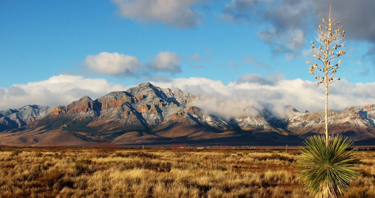
Peloncillo Mountains outcrop


The image above (click to enlarge) is a 4 image panorama taken on a sunny day.  Although similar in color, the outcrop in the foreground is differentiated from the valley floor by differences in texture.  While it is differentiated by color from the Chiricahua mountains in the background resulting in the appearance of an outcrop of rock that appears to float on the background.

creating depth in photographs
Hill in Animas Valley in southern New Mexico


This image is a low level aerial photograph with a tilt-shift effect added.  While employing an overall difference in perspective, in this case differences in contrast between the layers (shadow along the ridge top in comparison to the background desert floor) creates an edge resulting in increased depth.  This effect is enhanced by the tilt-shit which draws the viewer towards the area of increased depth which helps the viewer interpret increased depth in the photograph overall.


photograph of new mexico mountains
Low level aerial view of the Big Hatchet mountains
This image, also a low level aerial photograph of the landscape, relies on layered differences in color to enhance depth.  The foreground layer is brown while the background layer, with Big Hatchet Peak, is blue in color.  This layered color difference helps the foreground peak stand out against the background again resulting in increased depth.

Jhus canyon grave
Headstone in Jhus canyon


This final image, of a headstone in the Chiricahua mountains, uses color and texture differences to impart a sense of depth to the image.  The flat smooth brown headstone is contrasted against a background of shrubs and grass which differ in both color and texture again imparting a sense of depth to the image. 

This technique works at any scale from small to large landscapes, and is just a matter of composition.

While a number of different post production processing techniques may be used on a photograph, generally on a slight decrease in input levels and a slight increase in contrast suffice to bring out the layered depth in a composition.

Friday

Jhus (Whos) Canyon in the Chiricahua Mountains

Jhus canyon, pronounced WHOS, is located off the road into Whitetail canyon in the northern Chiricahua Mountains of southeastern Arizona.  Jhus canyon is a mid elevation hike on the north side of a ridge making it an ideal late winter/spring day hike. Sixteen members of the Portal Rodeo Hiking Club met up at the intersection of Foothills and Portal Road for a trip up Jhus canyon.  Upon driving up the access road a parcel of private land is reached and visitors must sign in and out when crossing private property.  A short distance beyond is parking at a gate onto public lands.

The trip started with a short detour to the grave site of Frank C. Caldwell.  A rough sandstone slab marks the grave which has offerings of pottery shards from a nearby Mogollon village and the inscription reads "Frank C. Cauldwell murdered July 26, 1903".  According to A Portal to Paradise Frank and another fellow, one-armed Jim Gould, were interested in the same women.  Frank had a prospect in Jhus canyon and frequently spent days at a time in Jhus.  One summer evening in 1903 Frank was exiting the canyon when he was shot in the back.  Jim eventually confessed to the killing and was tried for murder but claimed self defense.  He was convicted and sentenced to the territorial prison in Yuma.  After serving only 5 years he was released.  This odd occurrence was the result of the closing of the territorial prison in Yuma and moving it to Florence.  But Jim's sentence was specifically to Yuma so he was released, moving back to the San Simon valley. 

Next it was up the canyon.  Following the old road which parallels the stream bed the group headed up hill first stopping at the waterfall.  Perhaps 20-30' in height a dam below the falls was used to collect and pipe the water downstream, all now abandoned and silted in.  Continuing up the old track a large empty pool by an old homestead was encountered.  Varying in depth from about 3' to about 10' this "pool" may have also served as a water supply for either irrigation or household use as evidenced by several pipes leading out of the "pool".  Continuing up the stream bed/old road an old tailings pile was encountered.  Evidence of workings from sometime in the past.  Copper ore and pyrite were in evidence in the adit tailings.  Pushing on the group soon arrived at a second adit along the stream bed and the group adjourned for lunch along the stream bed.  The group then divided into 2 with half continuing to the ridge summit while the remaining members headed back down the canyon.  An easy 7 mile round trip it made for a nice late winter hike.  The map for this hike may be found in the sidebar or here

frank caldwell gravesite
Grave of Frank C. Caldwell at the mouth of Jhus canyon

waterfalls in southeastern arizona
Jhus canyon waterfall

southeastern arizona mineral resources
Copper ore in Jhus canyon mine tailings