Showing posts with label Portal Rodeo Hiking Club. Show all posts

Friday

Jhus (Whos) Canyon in the Chiricahua Mountains

Jhus canyon, pronounced WHOS, is located off the road into Whitetail canyon in the northern Chiricahua Mountains of southeastern Arizona.  Jhus canyon is a mid elevation hike on the north side of a ridge making it an ideal late winter/spring day hike. Sixteen members of the Portal Rodeo Hiking Club met up at the intersection of Foothills and Portal Road for a trip up Jhus canyon.  Upon driving up the access road a parcel of private land is reached and visitors must sign in and out when crossing private property.  A short distance beyond is parking at a gate onto public lands.

The trip started with a short detour to the grave site of Frank C. Caldwell.  A rough sandstone slab marks the grave which has offerings of pottery shards from a nearby Mogollon village and the inscription reads "Frank C. Cauldwell murdered July 26, 1903".  According to A Portal to Paradise Frank and another fellow, one-armed Jim Gould, were interested in the same women.  Frank had a prospect in Jhus canyon and frequently spent days at a time in Jhus.  One summer evening in 1903 Frank was exiting the canyon when he was shot in the back.  Jim eventually confessed to the killing and was tried for murder but claimed self defense.  He was convicted and sentenced to the territorial prison in Yuma.  After serving only 5 years he was released.  This odd occurrence was the result of the closing of the territorial prison in Yuma and moving it to Florence.  But Jim's sentence was specifically to Yuma so he was released, moving back to the San Simon valley. 

Next it was up the canyon.  Following the old road which parallels the stream bed the group headed up hill first stopping at the waterfall.  Perhaps 20-30' in height a dam below the falls was used to collect and pipe the water downstream, all now abandoned and silted in.  Continuing up the old track a large empty pool by an old homestead was encountered.  Varying in depth from about 3' to about 10' this "pool" may have also served as a water supply for either irrigation or household use as evidenced by several pipes leading out of the "pool".  Continuing up the stream bed/old road an old tailings pile was encountered.  Evidence of workings from sometime in the past.  Copper ore and pyrite were in evidence in the adit tailings.  Pushing on the group soon arrived at a second adit along the stream bed and the group adjourned for lunch along the stream bed.  The group then divided into 2 with half continuing to the ridge summit while the remaining members headed back down the canyon.  An easy 7 mile round trip it made for a nice late winter hike.  The map for this hike may be found in the sidebar or here

frank caldwell gravesite
Grave of Frank C. Caldwell at the mouth of Jhus canyon

waterfalls in southeastern arizona
Jhus canyon waterfall

southeastern arizona mineral resources
Copper ore in Jhus canyon mine tailings


Hiking with the Portal Rodeo Hiking Club

With winter snows at the higher elevations in the Chiricahua mountains the location for the weekly Portal Rodeo hike was at lower elevations in the Pelocillo mountains.  Twenty three hikers, including a number of visitors to the area gathered at the Chiricahua Desert Museum for the drive north.  After reshuffling hikers into 6 vehicles the group headed out.

Just south of I-10 on the east side of the San Simon Valley in the Peloncillo mountains lie several faults with old mines and prospects.  One of these, the Johnny Bull mine, "produced an unknown amount of copper, mostly before 1905" (1).  The site sits below McGee Peak on the west side of the Peloncillo mountains just across the ridge from the Carbonate Hill mine, another mine which produced lead, zinc, and silver.  Parking at the turnoff to the mine the group headed up hill.

The area is characterized by Mississippian aged Escabrosa limestone
with an intrusive band of volcanic rock.  Along the contact between these 2 groups and near the visible fault lines mineralization occurred and the mines and prospects are found along this interface.  Vertically oriented bands of mineralization may be seen at the surface and in the old adits and shafts, see below.  In the mine dump outside of one of the adits turquoise may be found.  Small pieces, light to medium blue in color, dot the dump that spills down the hillside.

The groups first stop was an old stone 3 room building.  Perhaps the mine headquarters, this building shows some interesting architectural details including arched windows and doors.  Continuing uphill the group came to 2 adits.  Above this were several vertical shafts with a headframe, and 2 ore shoots leading down to the level of the adits.  After some exploration, the group scattered with some heading south at the elevation of the headframe while others wandered back down hill before heading south across the exposed limestone slope of the Peloncillo mountains to other adits and prospects.  Passing a number of dugouts along the walls of the arroyos, these may have served as simple miners sleeping quarters.  Arriving at another major working the group took a break and ate lunch while looking for small chips of turquoise.  Similar to the other workings, this site was composed of 2 horizontal adits with a vertical shaft leading to the surface above the adits.  A bird, perhaps a raven, had built a large nest on a ledge in the vertical shaft next to an ore vein, see image below.  Sheltered from the wind and predators this nest still has a nice view of the greenery but in this case it is exposed copper mineralization.

A short winter hike of only about 3 miles, everyone seemed to enjoy a day out on the landscape.  The map for this hike may be found here or on the hiking page.

1.  Mining Districts of Hidalgo County, New Mexico

black and white old stone house
Old house at the Johnny Bull mine.


peloncillo mountains mine
Headframe at the Johnny Bull mine.


abandoned mine in the peloncillo mountains
The last load, an ore shoot below the headframe.
abandoned new mexico mine
The nest egg.  Bird nest next to ore vein.


southern new mexico mines
Mineralization in a vertical shaft.

Saturday

Hiking Maps of the Chiricahua Mountains

The Coronado National Forest lists 60 trails in the Chiricahua Mountains suitable for day hiking.  Enough to keep anyone busy for quite awhile.  But access to information about trails, difficulty, locations, and conditions is always changing.

The last commercial compilation of hiking trails in the Chiricahua Mountains was published in the late 1970's and used copies are still available.  Entitled "Hiking Trails and Wilderness Routes Chiricahua Mountains of Arizona" this publication was considered the authoritative guide to the Chiricahua Mountains by many.  But times change and access to information also changes.  The amount of web based information available has exploded and information on outdoor activities was not lost in the change.

In addition to trail information provided by the Coronado National Forest, users have also contributed information.  The Portal Rodeo Hiking Club is out weekly exploring the back country in the Chiricahua Mountains and maps of the hikes are published here, here, here, here, and here, and of course on this blog.  All of these maps are published through Google Maps and index independently in a Google search.  Bootheel Maps is another source of updated trail maps available for hikers.  These trails are all personally inspected, have additional information such as an annotated gazetteer, and may be printed out for field work.

The newest place to find Portal Rodeo Hiking Club maps is at Wikiloc.  Wikiloc is a layer in Google Earth found under Galleries (in the tool bar on the left).  This layer displays uploaded hiking maps of your favorite trails contributed by others.  This tool allows interested visitors access to information about hiking trails, in this case those hikes from the Portal Rodeo Hiking Club.  These maps are linked to the original Google Maps of each hike where additional photographs, contributed my hikers, may be viewed. Or alternatively, the "photos" layer may be activated to view other Google Earth photographic submissions.

Below is a sample map of the trail up Silver Peak in Cave Creek Canyon from Wikiloc.  To view additional hiking maps, open Google Earth and click on the Wikiloc layer under the Galleries tab.  As time permits additional maps will be included in Wikiloc.


Addendum: A list of maps uploaded to Wikiloc may be found here.

Friday

South from Sulphur Canyon

Along the east face of the Chiricahua Mountains there are a number of small unnamed canyons that act as drainage for water from higher elevations in the mountains.  This weeks hike with the Portal Rodeo Hiking Club was along the east face and up one of these smaller canyons below Magnus Dome.  Starting in Sulphur Draw 14 members of the hiking club and one dog headed south along the east flank of the Chirichuas hiking through open grasslands recovered after the Horseshoe 2 fire last year.  Ungrazed, the grasslands appear to have recovered nicely with a carpet of grass over a foot tall across the lower slopes of the Chiricahua Mountains.  The first stop was a wildlife watering station.  Consisting of a large concrete apron connected to a underground cistern the watering station has a small open pool for wildlife.  Continuing south along the slope with magnificent views of the San Simon Valley and the Peloncillo Mountains the group eventually started climbing up a small canyon.  At the base of the cliffs the group stopped at the granary.  Perched on a ledge in a shelter cave, the granary is a mud, stone, and wooden structure that was used for food storage sometime in the past.  The presence of wood in the structure suggests it is of historic construction, possible Apache though no confirming pottery or other material was present.  This site as well as other shelter caves in the area have been mapped and studied by the Forest Service as evidenced by survey pins.

Leaving the granary the group continued up the canyon past fading petroglyphs on the cliff walls to 2 shelter caves with evidence of occupation.  Hidden behind large pieces of breakdown from the cliffs above and not visible from below these soot covered shelters were home to someone in the past.

The final stop for most of the group was another shelter cave even higher up the canyon with a keyhole view out onto the valley.  At that point the group divided into 2 with the majority heading back down the canyon while a hardier group continued up looking for a route to the top Magnus Dome.

Although only 3 miles was covered, hiking across the steep inclines made the trip more difficult. 

For a photograph from inside the granary please follow this link.

aouthern arizona landscape
Portal Peak from Sulphur Draw

apache food storage site
Granary or a room with a view

southern arizona landscape
A view through the keyhole

Wednesday

A Trip to Paradise

Just before Christmas the Portal Rodeo Hiking Club weekly hike was a trip to Paradise.  Starting at the old corral on FS 42 (1 mile past the research station on the right) 10 hikers and 2 dogs headed up a ridge on the south west side of Silver Peak for a trip to Paradise AZ. Cutting cross country the group eventually found the trail and headed up the drainage toward the ridge top.  Passing a number of old gabions placed for erosion control the gentle incline made for easy walking.  Upon reaching the ridge top and passing through a gate the group headed down hill to eventually meet FS42B just outside of Paradise.  The return trip followed a slightly different route with a side trip for lunch on top of a knoll just below the Elephant rocks.  Following the main drainage and trail the group ended up in a large meadow before returning to the cars.  Covering about 6.4 miles with less than 500' of elevation gain an easy outing for a nice winter day.  The map of this hike may be found here.

Old corral in the Chiricahua mountains


Gabion in the drainage
The Chiricahua mine above Paradise

Saturday

Owl Canyon

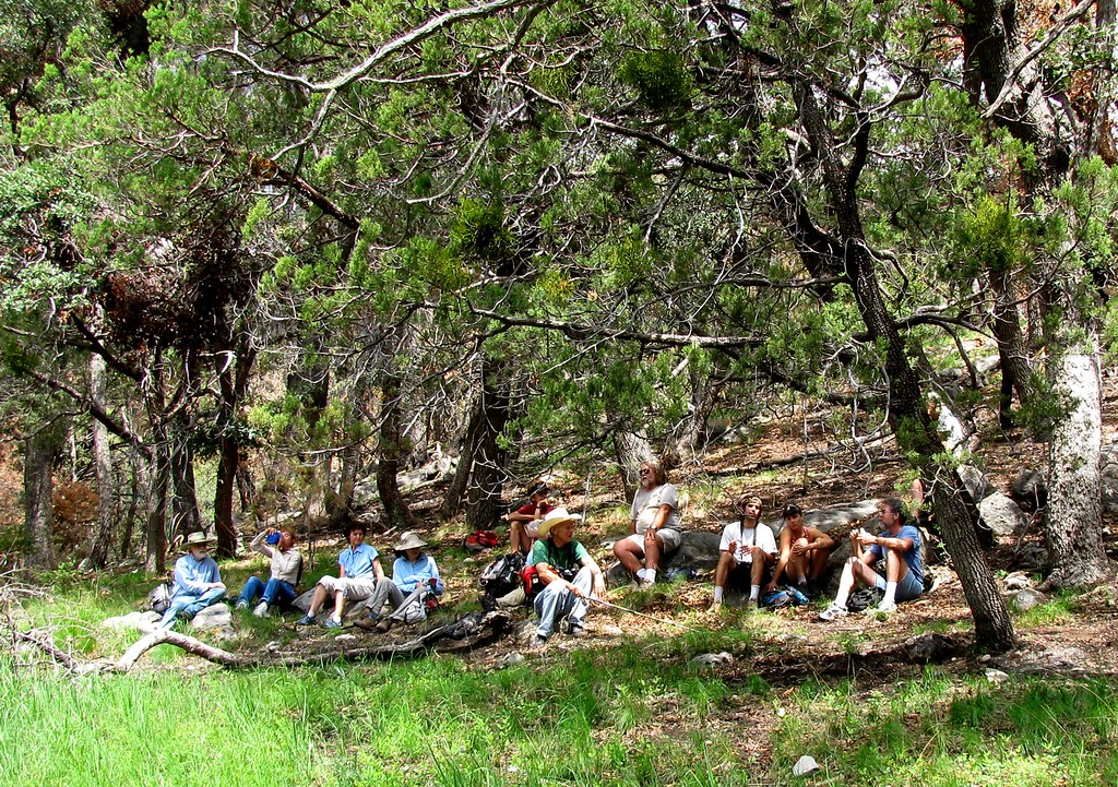
Back to Owl Canyon was the mantra this week for the Portal Rodeo Hiking club.  Lower elevation hikes in the Pelocillo Mountains are especially attractive in the winter with hiking at warmer elevations and it was another sunny day in the valley as 13 hikers and a single dog began the trip up Owl Canyon.  About 1.5 miles in the group stopped at the dam for a break and group photograph.  Lunch was below a large spire in the canyon with the group scattered up the hillside eating and enjoying the views.  The trip covered 6.6 miles and the map for the hike may be found in the sidebar or through this link.

North ridge line in Owl Canyon
Photograph of Portal Rodeo Hiking Club at the dam in Owl Canyon by Pat Owens

lunch in owl canyon, The Portal Rodeo Hiking club stops for lunch in Owl Canyon
Lunch in Owl Canyon

Friday

Chiricahua Mine with the Portal Rodeo Hiking Club

This weeks hike with the Portal Rodeo hiking Club began in the historic former mining town of Paradise Arizona north of Cave Creek Canyon.   Paradise traces its' roots to 1901 with the Chiricahua Development Company work on the Chiricahua mine.   Two shafts were sunk and several other adits are found in the area as well as a 2 story stone building just south of the shafts.

The area was heavily burned in last years Horseshoe Two fire and evidence of high intensity burn are visible.  While the hillsides are covered in grasses and new growth, little new growth at the base of the trees is apparent.  The stream bed experienced significant down cutting with erosion channels up to 5 ft deep in places, a result of last years monsoon rains.  With the loss of vegetation the geology and evidence of past inhabitants is visible across the landscape.  The route along the old road is littered with artifacts from the development of the mine.  Small donkey shoes, tools, and pieces of machinery were found along the stream bed as well as iron/iron ore and evidence of copper.

Granite is visible at the mine entrance and in the mine dump indicating the shafts reached through the overlying limestone into an intrusive granite zone that was probably the source of the copper ore which filtered along the contact zone resulting in mineralization.  Although the mine was not successful it gave Paradise its start.

The hike covered 5.7 miles (including the detour up a side drainage) with an elevation change of 750'.  Thirteen hikers and 4 dogs made the trip including the Gypsy Carpenters who were back in town for Portal Irish Music week.  The map for this hike may be found at the following link.


Hiking route to the Chiricahua mine above Paradise. 

Erosion channel

Building site at the Chiricahua mine.

Shaft at the Chiricahua mine

Oak tree above Paradise

Paramore Crater with the Portal Rodeo Hiking Club

In a celebration of spring in the valley and the arrival of the poppies the Portal Rodeo hiking club visited Paramore Crater.  One of several volcanic maar craters, Paramore Crater lies south of the drainage divide separating the San Simon Valley and San Bernardino Valley.  Located on a private ranch, permission was granted by the rancher for the hiking club to travel across the ranch to the base of the crater for this hike.  Covering about 5 miles with only about 400 ft of elevation change, the crater is a spectacular viewing point for spring wild flowers blooming in the San Bernardino Valley.  The surrounding cinder cones in the Geranimo lava field, part of the Boot Heel volcanic field, were carpeted with yellow poppies and bladderpods and the color grew more intense as the day progressed.

Named in honor of James Harrison Parramore, who in partnership with Claiborne Walker Merchant created one of the early ranches in the San Simon Valley the San Simon Cattle and Canal Company, the crater is a result of the interaction between lava rising towards the surface and ground water.  The resulting steam explosion leaves a large circular crater often mistaken for a meteor impact site.   Two other maar craters are found to the southwest of Paramore Crater.  One is similar in size to Paramore Crater while the smaller one is known as Neville Crater.

After an easy walk to the rim of the crater, the group dropped down to the crater bottom and crossed the crater to the east making their way through head high native grasses.  After visiting the main drainage into the crater and viewing the old dam on the southeast corner, the hiking club climbed up the southern lip stopping for lunch.  Exposures of the underlying basalt held inclusions of obsidian and eroded obsidian was visible on the trail along the south rim.  Evidence of early habitation was also found along this southern lip and included chipping and flaking, some hand scrappers and a broken metate.  The route of this hike may be found on the hiking page or here.


Topographic map of Paramore Crater


Point cloud of Paramore Crater from the interactive Photosynth Flying Below Ground Level

Hiking with Poppies
Ghost in the Grassland

Rucker Canyon in the Chiricahua Mountains

An exceptional day combined with an exceptional hike best describes this outing with the Portal Rodeo Hiking Club.  The group headed out at 8:00 AM from Portal and meeting additional hikers in Rodeo before heading south to Rucker Canyon.  The site of a former Army supply post from the 1800's Rucker Canyon has a number of nice campgrounds along the lower reaches of the canyon.  Parking at the end of the last campground 20 hikers and 2 dogs headed upstream and up canyon along the Rucker Trail 222 in the shade on a cool January morning.  About a mile up the canyon, a series of water worn pools in the rhyolite were encountered, a very photogenic location.  While the west canyon wall was illuminated by the early morning sunlight creating some spectacular views of the vertical lichen covered rhyolite walls.  The sun eventually crested the ridge illuminating the canyon floor and providing additional warmth while following the trail.  The trail eventually departed the stream bed where Rucker Canyon turns west and the group followed a series of switchbacks up the ridge where everyone stopped for lunch and surveyed the extent of the Horseshoe Two Fire.  While the visible ridgetops showed signs of significant fire, the lower elevations and the canyon bottoms saw only ground fire which cleared out the small trees and underbrush which will lead to a healthier forest.

The hiking club covered a little over 4 miles (8 miles round trip) and 1500 ft in elevation gain to reach the ridge top.  The map for this hike may be found in the sidebar or at this link.

As a side note, the lunch stop on top of the ridge was only about a quarter of a mile, and 500 ft. above the trail in Price Canyon hiked last year, a distance by vehicle (from trailhead to trailhead) of over 30 miles.

Reflections in Rucker Canyon


The gates in Rucker Canyon

Trail sign near top of ridge

Saturday

San Bernardino National Wildlife Refuge

The Portal Rodeo Hiking Club combined several locations on their most recent outing.  The first was a visit to the San Bernardino Wildlife Refuge east of Douglas AZ.  This refuge, about 2300 acres in size, sits in the middle of the San Bernardino Valley and abuts the border with Mexico and the Slaughter Ranch.  It is a low basin area and the headwaters of the Rio Yaqui flowing south through northern Mexico.  A number of ponds support endangered fish species and historically was home to quarter of Arizona's endangered fish species.  An easy loop of 4.2 miles following roads allowed the hiking club to circumnavigate a number of ponds in refuge with a section along the border.  The map for this hike may be found here or on the hiking page (tab at top of the page).

Wildlife pond in the San Bernardino National Wildlife Refuge

Border Monument

Friday

Hummingbird Springs

This weeks Portal Rodeo hiking Club hike was a return to Hummingbird Springs on the east flank of the Chiricahua Mountains.  The hike started at Naturalist Journeys outside Portal Arizona with hot juices, tea, and coffee cake before heading off into the Coronado National Forest.  About 2.5 miles into the hike, past Hummingbird Spring, the group divided up with the majority pressing onwards while several hikers headed back to attend to holiday business.  Returning with the other hikers was an opportunity to check out a shelter cave in the quartzite and wander around the old Cienega at the base of hill outside Portal identified on old topographic maps.  Covering only about 5.5 miles while the main group traveled about 8 miles it was another nice day in the forest.  The map showing a trail route is here and in the sidebar.

View from a shelter cave in the Chiricahua Mountains

Saturday

Round Valley in the Chiricahua Mountains

Round Valley in the Chiricahua Mountains is an isolated valley in the foothills just northeast of Paradise. Lying at a low elevation it is the perfect winter hiking area which is easily accessible from Foothills Road and was chosen for this weeks hike with the Portal Rodeo Hiking Club.  Round Valley is known primarily for the Arizona Game and Fish Departments 560 acre May Memorial Wildlife Area which was the site of the former "Round Valley Ranch".  But there is also Arizona State Land, BLM land, and some private land in the valley.  Access is across private land, either through a gate on the south end or up a wash on the north end.  Both routes lead west through short canyons which open into the valley.  The May family is buried in the wildlife area (father, mother, and son) near the monument commemorating the wildlife area and their story is recounted in the book A Portal to Paradise.  The hiking club traveled, ambled, walked about 8 miles wandering along some old roads visiting homesteads and old mines that are scattered throughout the valley.  The hiking map may be found in the side bar or here.  A 360 degree panorama of Round Valley is also available for viewing.


Round Valley hiking route with land ownership overlay.
Land Stewardship Key:
Blue - Arizona State Land Department
Yellow - Bureau of Land Management
Green - Coronado National Forest
Orange - Arizona Game and Fish (May Memorial Wildlife Area, 560 acres)
Clear - Private land

May Memorial Wildlife Area 
Looking into Round Valley

Friday

A Walk in the Park

The title was a group effort and I believe others are posting under the same title.  It seemed appropriate since the walk with the Portal Rodeo Hiking Club started and ended at Barfoot Park in the Chiricahua Mountains.  Barfoot Park was designated as a National Natural Landmark earlier this year and the hiking club had not visited in awhile.

It has been my experience that there are 2 kinds of outings with the Portal Rodeo Hiking Club, walks and hikes.  An outing only qualifies as a hike if there is over 5 miles covered and at least 2000’ of elevation gain.  This weeks outing was only 3 miles with a little over 1000’ of elevation gain so qualifies only as a walk.  It differed from other outings in that half of the walk was off trail.  Starting from Barfoot Park 7 walkers, and 4 dogs, headed down hill along the old road from Barfoot Park toward Methodist Camp.  After loosing a significant amount of elevation the group headed uphill following no particular trail, just bushwhacking.  The area was one which the BAER team had scheduled for aerial reseeding after the Horseshoe Two fire.  As a result the group walked to thigh high barley (sterile) which covered the ground.  This area on the west side of the mountains was hard hit by the fire and the reseeding effort was designed to prevent major erosion in this burned area.  While traversing the high elevation barley crop, the ensuing discussion centered on starting a brewery using the sterile barley, which at the time seemed like an eminently practical idea, but I doubt little will come of the discussion.

Upon returning to Barfoot Park several members explored around the spring.  The spring was flowing well and producing cool refreshing water.  Of course the dogs had to explore also getting wet and muddy in the outflow flowing across the park.

The map to the walk may be found through the following link or in the sidebar.

Effects of aerial reseeding in the Chiricahua Mountains
Spring at Barfoot Park

Tree along the ridge west of Barfoot Peak

Portal Rodeo Hiking Club: On Top of the World

With the reopening of the remainder of the Chiricahua Mountains in the Coronado National Forest last week the Portal Rodeo Hiking Club took the opportunity to get into the high country to view first hand the results of the fire along the Crest Trail.  On the drive to Rustlers Park everyone stopped to admire a Mountain King snake near the Basin Trail head, a beautiful animal.  Upon reaching Rustler's Park the group parked at the entrance before the gate (the camping area is currently closed) and hiked up to the Crest Trail and headed south.  The hiking club was met with a profusion of wild flowers carpeting the higher elevations of the Chiricahua Mountains.  After stopping for a break at Bootleggers Saddle the group headed on to the intersection of several trails at the base of Flys Peak.  One group of hikers continued along the Crest Trail to Anita Park while the rest headed to the summit of Flys Peak.  After lunch on top of Flys Peak and a decent down the south side to Round Park the group divided again with several hikers heading to Bear Wallow on the east side while several others hiked back along the Crest Trail on the west side covering about 6.5 miles with 1300 ft of elevation change.  The hiking map may be found here or in the sidebar.

Mountain King snake near the Basin Trail.


Along the Crest trail.


View from the Crest trail NW across the Chiricahua Mountains

The Basin Trail with the Portal Rodeo Hiking Club

The Portal Rodeo Hiking Club tackled the Basin Trail in the Chiricahua Mountains this week. The Basin trail (#246) is an easy lower elevation hike starting on Forest Service Road 42. Climbing 500’ in the first mile the trail descends for the remaining 4 miles arriving at Herb Marytr day use area. The hiking club added a side trip to Ash Springs for lunch before continuing as 2 separate groups. One group headed to Herb Marytr to pick up a car while the other group continued along the stream down to FS 42 and then back along the road past the research station to the original meeting place.  The respective distances hiked were 5+ miles and approximately 9 miles.

The forest is in good condition, all the streams were running clear, but the route passes through several areas where effects of fire were evident. With the arrival of the monsoons there is ground cover and many trees thought to be lost with the fire show evidence of new growth. A single rock rattle snake was found along the trail hiding under a small shrub along the trail. It sat quietly while photographed.  Below is a screenshot of the route taken and some of the sights along the way.  The hiking map may be found here or in the sidebar.


Basin trail and side trip to Ash Spring

Yucca with seed pods on the Basin Trail


A view south from the Basin Trail

Lunch at Ash Spring with the Portal Rodeo Hiking Club.  Chiricahua Sky Island Rodeo

is hiding behind the tree on the left.


Thursday

Habitat Change not Habitat Loss

The Coronado National Forest has started to reopen since the monsoons are underway.  The Chiricahua Mountains are partially open but some closures remain in effect until hazard trees are removed and road stability is assured.  The Portal Rodeo Hiking Club made it's first trip since the start of the Horseshoe Two Fire.  The route chosen was from the Visitors center outside of Portal Arizona up Cave Creek Canyon, then up and down South Fork Canyon, and continuing up canyon to just short of the American Museum of Natural History South West Research Station. The walk up canyon covered about 5.5 miles one way and a large group with 8 dogs made the first hike completely in the riparian canyon bottoms.

Over the past several weeks there was discussion about "habitat loss" as the result of the fire, but that is changing to the term "habitat change" as people realize that nothing was lost but instead the mountains experienced a rapid change.  To pay homage to that idea below is an image that illustrates change.  The image was desaturated, inverted, hue and saturation changed, and then inverted a second time.  While the color is different it is still a beautiful canyon and mountain range, still worthy of the designation "sky island".

The map of this hike up Cave Creek Canyon also appears in the sidebar.

Friday

Chiricahua Mountains, Price Canyon, Trail 224

The goal:  A return trip to Price Canyon with the Portal Rodeo Hiking Club to clean up refuse along the trail.   Meeting in Rodeo, a group of 7 hikers and 3 dogs headed south for Price Canyon.  About 7.5 miles from Highway 80 the group reached the trail head in Price Canyon, trail 224, and headed up canyon with garbage bags for refuse.  To the groups surprise the vast majority of trash had been removed including bags previously filled by members of the hiking club.  The trail was in good shape and an easy 3 mile walk up canyon to the junction with Baker Canyon.  Several of the members turned around at point but 3 continued up canyon finding refuse to collect and brought out several bags of trash.

While investigating a rock face off the side of the trail my first snake of  the season was found.  A small Western Twin-spotted rattlesnake, Crotalus pricei pricei, was observed on a fallen branch on the hillside.  Characterized by dark twin spots running the length of the dorsal surface which merge toward the tail and a dark band running laterally behind the eye, this rattler quietly sat on the log and allowed photographs.

The total distance covered was about 8 miles for the those hiking past the Barker Canyon/Price Canyon fork and about 6 miles for those who returned from the fork, with an elevation change of 1150 feet to the fork from the trail head.  The map may be found either in the sidebar or at the following link


Price Canyon Trail

A Lone Pine Between two Crags

Horseshoe Canyon Redux

Another trip into Horseshoe Canyon with the Portal Rodeo Hiking Club.  The group drove up the canyon to the second gate to begin the hike.  As opposed to the hike several months ago which was open grasslands, this hike stayed in narrower parts of the canyon.  Stopping first at a shelter cave on the hillside where evidence of occupation (faded pictographs, chipping and flaking) this shelter cave has see use into historic times with use by ranch hands, migrant workers, and timber thieves.  Continuing up the canyon along the road we came to the old Ronsh Ranch (pronounced Raush).  This old homestead sits slightly above the bottom of the canyon and all that remains is the old chimney.  Further up the canyon a trail to the south leads up Blevins Draw and tops out at Jack Wood Pass where the group stopped for lunch before returning. Fresh bear tracks were found in Blevins Draw, one headed down canyon and about 3 feet away one headed up canyon.  It was suggested the bear was headed down canyon, heard the hiking group and turned around.  The hike covered 8.75 miles with 800' of elevation gain along the route.

The map is in the sidebar or may be found at the following link.

Google Earth map of hiking route

Bedrock mortar at the shelter cave


Fresh bear track
View up Horseshoe Canyon from above the Ronsh Ranch.