Showing posts with label Chiricahua Mountians. Show all posts

Tuesday

How do People See? Again

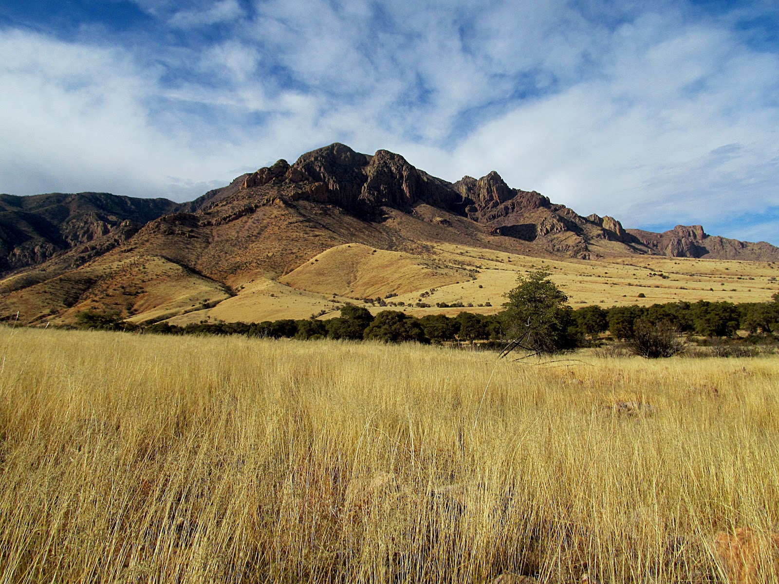
I continue to struggle with the concept of "how people see", specifically how it relates to what makes an interesting photograph.  Recently, I stumbled into a little experiment using Facebook and ended up posting 3 images and comparing their performance.  The metric I used was a "like" indicating a positive response from a viewer.  The 3 images were taken from the same location (mouth of Sulphur Canyon but of 2 different subjects) and posted on 3 consecutive days (Friday through Sunday).  Image 1 was of a view towards Darnell Peak, a multi-image panorama but presented in Black and White.  After spending several hours on creating the image I was very pleased with final outcome and posted it.  Image 2 was a simple snapshot of Portal Peak and presented in color, while image 3 was another multi-image panorama of Portal Peak also presented in color.  My expectation was the first image would preform the best.  It was a good composition, with the volcanic walls of the Chiricahua mountains rising up from the grasslands, the moon in the background, nice shadowing, and crisp details that draw the eye into the scene.  Yet after several days it received only 35 likes so I added the snap shot of Portal Peak (image 2).  Surprisingly, the quick snapshot with the top of Portal Peak in shadow, the result of a passing cloud, picked up 87 likes and was featured as a group cover image where it picked up an additional 70 likes.  I then added the final multi-image panorama, a "big picture" view, which received 46 likes.  In terms of work load the most time was spent creating image 1, the next was image 3, and image 2 (the snapshot) took the least amount of time.

Image performance, whether in the form of views or likes is important since I use the imagery as a way to create interest in the area and in the long run generate business for the Painted Pony Resort.  I can only conclude that color performs better than Black and White, and color contrast in an image is more appealing than the scope of an image.  Finally, the amount of work spent creating an image is not proportional to its public appeal.

I still like the first image the best.

Image 1, Looking up towards Darnell Peak on the south side of Sulphur Canyon.


Image 2.  Portal Peak from the south side of Sulphur Canyon.

Image 3.  Portal Peak and the mouth of Sulphur Canyon.

Sunday

Photographing the Same Subject Over and Over

I frequently take and post images of the eastern side of the Chiricahua mountains as seen from around the Painted Pony Resort outside Rodeo New Mexico.  I have so many images of the same subject that a slideshow entitled "The Many Faces of the Chiricahua Mountains" was created.  The goals in constantly photographing Portal Peak and the eastern Chiricahuas are to create the perfect image as well as photo-document the changes in the landscape that create different moods I experience when observing the mountain range over time.  But what constitutes a perfect image of the Chiricahua mountains?  

From my perspective, several factors are important.  The first is scale.  Scale in this case refers to the physical distance encompassed in the image.  The landscape image below spans 5.75 miles in length, Cave Creek Canyon south to Sulphur Canyon, and 4000' in height, the floor of the San Simon valley to the top of the 8000' Portal Peak.  Since most cameras do not capture scale without forcing the subject into the background my landscape images require construction in a post production process.  A good image editor is required to piece together segments of the landscape taken closeup into a final product that recreates what I see with my eye, is pleasing to view, and encompasses the whole scene.  Since I shoot hand held with an inexpensive point and shoot camera this takes composing the final image in my mind and then collecting the individual elements for later construction.

The second factor is lighting.  Early morning just at sunrise is always the most productive time to capture images of the eastern flanks of the Chiricahua mountains.  The long light of the rising sun creates a series of colors, some lasting only a moment, across the flank of the mountains.  Starting in the reds the colors move in shorter and shorter wavelengths through the blues until the reflected colors begin to wash out.  

The third is color.  This is of course related to the lighting.  But in some cases, especially when clouds are present over the mountains and the shadows stark a presentation in black and white is more striking and evokes stronger emotions so I choose to desaturate the image after increasing contrast to to further enhance the elements of light and shadow.  

Finally depth.  A number of tools are available to enhance depth in a photograph and perhaps the most common is depth of field.  I have chased after techniques that enhance depth in 2 dimensional images to create a more realistic 3 dimensional image in the belief that good depth enhances the viewers experience. The image below shows good depth with dark clouds creating shadow over the ridges in the background while the foreground ridge line is complete sunlight.  This contrast in shadow naturally enhances the appearance of depth in the image making the almost 6 miles of ridge line stand out and away from the shadowed background.  This difference in shadowing was the result of the partial cloud cover present at that time and in combination with an old photographic technique developed in Germany in the 1930's, further enhances the depth.  Unsharp masking creates an apparent increase in resolution and is a useful tool for creating an image with increased depth helping the foreground ridge line jump out of the image. 

These are all easy to apply tools that anyone can implement to create images that capture the imagination and convey the emotions generated when viewing the scene.


black and white view of Portal Peak
Almost perfect, click on the image to see a larger version or follow this link.
Addendum:
More work with the original panoramic image data set has resulted in this new image.  Spanning further south and north, both Portal Peak and Darnell Peak are visible and the scene shifts from just Portal Peak to the whole east flank of the Chiricahua mountains. 


Wednesday

2014 Monsoon Season in Southwestern New Mexico

The monsoon season is well underway and the mountains on both sides of the San Simon valley are receiving good rains.  But out in the middle of the valley it is a little slower.  The Painted Pony Resort has received about 6" so far this year and hoping for more.  Yesterdays rain was heavy in both the Peloncillos and Chiricahuas but we received only 0.07".  This morning though the views were nice and I took some time from cleaning to capture the image below.  Desaturated, the image is just one of the many faces of the Chiricahua mountains, always changing with the light and seasons.  Always something new to see.

The 8000' Portal Peak on the east side of the Chiricahua mountains

Sunday

One More Image from the McCord Tail

Although not the best weather conditions for landscape photography, with some work one image did turn out.  A desaturated view from the overlook on the McCord trail, looking west across Cave Creek Canyon is shown below.  By desaturating the colors the differences in texture create a layered 3D effect with the rock outcrops appearing layered upon one another (click on the photograph to get a larger image).  This creates a diagonal composition with layers of rock outcrops running from the upper left (background layer) down to the lower right (foreground layer).  The layering effect is mirrored by the shadows which also run from the upper right to the lower left.  Notice also how the edges of the rock outcrops are sharp and crisp which lends to the layering effect and enhances the 3D appearance of the image.  All in all, a pleasing image of the landscape.

rock outcrops
A view from the McCord trail above Cave Creek Canyon in the Chiricahua mountains.

Waterfalls of the Chiricahua Mountains

Waterfalls are inspiring, evoking images of cool mountain streams and dense lush forests, but in the desert southwest there are also many waterfalls.  Found in the sky islands of the basin and range province of the southwest these desert waterfalls rely on moisture from the winter rains and summer monsoons for their displays.  Depending upon the time of year these waterfalls may range from a trickle to something truly spectacular to see.  In the Chiricahua Mountains of southeastern Arizona the best known waterfall is Winn Falls.  This 400 ft high waterfall is viewed from the Greenhouse trail and may explain it's familiarity to many.  But there are a number of other waterfalls without names which are not as familiar.  These seldom visited sites are high in the interior of the Chiricahua Mountains and access takes time and energy since these waterfalls are off trail and generally require a significant elevation gain to reach.  An interesting observation about the waterfalls in the Chiricahua Mountains is their location.  A string of waterfalls is is located on a north/south transect in the interior of the Chiricahuas, see below.  Each waterfall or set of falls is reached by hiking up a series of canyons that bisect a band of harder material that comprise the base material of each waterfall.  This line of waterfalls may be extended north and south where other little know waterfalls may exist, but will require some further exploration to to test this idea.

coronado national forest waterfalls
Waterfall transect in the interior of the Chiricahua Mountains.


Friday

A Walk in the Park

The title was a group effort and I believe others are posting under the same title.  It seemed appropriate since the walk with the Portal Rodeo Hiking Club started and ended at Barfoot Park in the Chiricahua Mountains.  Barfoot Park was designated as a National Natural Landmark earlier this year and the hiking club had not visited in awhile.

It has been my experience that there are 2 kinds of outings with the Portal Rodeo Hiking Club, walks and hikes.  An outing only qualifies as a hike if there is over 5 miles covered and at least 2000’ of elevation gain.  This weeks outing was only 3 miles with a little over 1000’ of elevation gain so qualifies only as a walk.  It differed from other outings in that half of the walk was off trail.  Starting from Barfoot Park 7 walkers, and 4 dogs, headed down hill along the old road from Barfoot Park toward Methodist Camp.  After loosing a significant amount of elevation the group headed uphill following no particular trail, just bushwhacking.  The area was one which the BAER team had scheduled for aerial reseeding after the Horseshoe Two fire.  As a result the group walked to thigh high barley (sterile) which covered the ground.  This area on the west side of the mountains was hard hit by the fire and the reseeding effort was designed to prevent major erosion in this burned area.  While traversing the high elevation barley crop, the ensuing discussion centered on starting a brewery using the sterile barley, which at the time seemed like an eminently practical idea, but I doubt little will come of the discussion.

Upon returning to Barfoot Park several members explored around the spring.  The spring was flowing well and producing cool refreshing water.  Of course the dogs had to explore also getting wet and muddy in the outflow flowing across the park.

The map to the walk may be found through the following link or in the sidebar.

Effects of aerial reseeding in the Chiricahua Mountains
Spring at Barfoot Park

Tree along the ridge west of Barfoot Peak

Saturday

A Drive up Cave Creek and South Fork Canyons in the Chiricahua Mountains

A virtual drive up Cave Creek and South Fork Canyons in the Chiricahua Mountains after the Horseshoe Two Fire.  Permission was granted for a group of business owners from Rodeo and Portal to visit the interior of the Chiricahua Mountains before the closure was lifted to assess first hand the effects of the fire.  The group was accompanied by the BAER Team information officer, a safety officer, and a member of the Forest Service.  This video covers the drive from Portal to the day use area at the end of the South Fork Road.  The editing cuts in the video were for time and not content.  The goal is to provide visual information about the state of the Riparian areas at the bottom of the canyon after the fire.

Tuesday

The 1919 Hike

Last week's hike with the Portal Rodeo Hiking Club resulted in another hiking map of the Chiricahua Mountains.  But with access to the 1919 topographic map of the Chiricahua Mountains and out of curiosity the data was placed on the old topographic map for comparison.  While Rustler Park is on the 1919 map, Methodist Camp and many other named features are absent.  Most importantly FS42 did not exist at that time and the hike, if done in 1919, would have been much much longer.

The hike in 1919

Saturday

Found it in Cave Creek Canyon

Currently have guests in residence at the Painted Pony and one couple Geocaches.  On Saturday while leading another hike up South Fork Canyon in the Chiricahua Mountains we stopped and investigated the location of Trogon's Treasure.  Located up a short trail and near a scenic overlook in the canyon the geocache was discovered by the party of 6 hikers and everyone signed the log after investigating the goodies in the cache.  The location is straight forward and made for a nice warm up to the days hike.

backside of Trogon's Treasure

Trogon's Treasure

Friday

Portal Rodeo Hiking Club 12-02-2010, Around Cochise Head

A large turnout of 20 22 hikers arrived at the corner of Foothills and Portal Road Thursday morning for the weekly Portal Rodeo Hiking Club hike.  The group caravan took everyone up Whitetail Canyon past the vineyards to a pullout along the creek bed where destination decisions were debated.  The club divided into 3  4 groups, 2 groups headed to Cochise Head (or the saddle), and 2 others (a fast and slow group) headed to a shelter Cave at the base of Cochise Head.  After an nice 3 mile walk on this cloudless day, with only 1200' of elevation gain, the fast group and one member of the slow group arrived at the shelter cave.  The south facing shelter cave, located in the rhyolite at the base of Cochise Head, is only about 50' in depth with a heavily sooted ceiling.  There is evidence of both historic and prehistoric use.  The remains of an old stove sits just outside the entrance along with broken jars and bottles.  Prehistoric use is evidenced by faded pictographs on each side of the entrance.  Newer graffiti overlays pictographs on one side while the panel on the other side is intact.  Someone mentioned the shelter cave was the source of  roadside attraction "The Thing", but NPR provides an alternative view which is probably more accurate.  After the hike the group reconvened at Wynne's house just down the road and was treated to brownies and coffee.  A refreshing end to a beautiful day.

Google Earth Screen shot of Trail

Portal Rodeo Hiking Club on the Trail

Shelter Cave at the Base of Cochise Head

Faded Pictograph

Sunday

Found It, Geocaching in the Chiricahua Mountains

Having found the Rodeo, New Mexico geocache and the Silver Peak geocache, and with a couple of free hours another search for a local geocache was started.  After reviewing the map of geocaches in the Chirichua Mountains in southeastern Arizona, 2 seemed straight forward candidates for an afternoon search.  Both caches lay off Forest Service Road 42B, the road from Portal to Paradise, and both were named for the near by town of Paradise, Arizona.  "The Road to Paradise" and "Eternal Paradise" were straight forward discoveries and involved short strolls through the lower elevations of the Chiricahua Mountains.  The Road to Paradise was found next to the road along the base of the ridge that extends north of Limestone Hill.  While Eternal Paradise was just another mile up the road near the Paradise Cemetery.  A stroll through the cemetery was an interesting way to spend a couple of hours and there are some unique markers especially the cast tree limb with a spider web.  The earliest birth date is 1828.  It is interesting to note there is a cattle guard at the entrance to the cemetery, an unusual feature.

Road to Paradise Geocache

Eternal Paradise Geocache

Paradise Cemetery with Cattle Guard

Gifts to the Dead

Tuesday

Barfoot Lookout atop Buena Vista Peak, Chiricahua Mountains, Arizona

It was crowded atop Buena Vista Peak when we arrived.  A work crew was already at work installing a repeater for Border Patrol communications and a mule wrangler with 4 animals arrived with another load of equipment shortly after we reached the lookout.  After the drive up into the Chiricahua Mountains from Cave Creek Canyon without seeing traffic then a quiet walk up a mile of trail, arriving to find a group of people and mules seemed like we had stumbled upon a secret meeting in the mountains.  The view from the fire lookout is spectacular and considering the ease of the trail and the minimal elevation change, this trail should rank high on anyone‘s list of Arizona New Mexico peaks to visit.

The trail to the Barfoot fire lookout is an easy 1.2 miles and gains less than 300’ in elevation between Rustlers Park campground and the top.  The trail starts at about 8500’ and ends at approximately 8800’ winding through tall Ponderosa Pines on a well maintained trail.  It is a short segment of the Crest Trail, trail 270, which is a series of trails running the length of the Chiricahua Mountains.

Google Earth screen shot of trail from Rustler Park to the Barfoot Lookout

Crest Trail to Barfoot Lookout

Stairway to Heaven on the way to the Barfoot Lookout

Secret Meeting at the Barfoot Lookout

Friday

Portal Rodeo Hiking Club - November 12, 2010

This weeks hike, in honor of the Gypsy Carpenters, was up Silver Peak in the Chiricahua Mountains.  Started at 8:00 AM with 2 others from the Portal Rodeo Hiking Club while the main party started at 9:00 AM from the Silver Peak trail head, trail 280, just beyond the Forest Service visitors center in Cave Creek Canyon.  It was a cool morning in the canyon and on some of the north facing slopes there were small patches of light frost on the ground.  We took a break at the overlook about 1000' from the top and regrouped for the final push to the summit.  The hike involves 3000' of elevation change along the advertised 4 1/2 mile trail and was in good shape.  At the top we ate lunch on the old fire lookout station foundation and Chiricahua Sky Island, Rodeo went hunting for benchmarks to record.  Then back down the mountain.  Below is a screen shot from Google Earth of the trail route and the interactive map is in the sidebar or here. 


Screen shot of Silver Peak trail, trail 280. Click on photograph to enlarge image.

Lunch on the old foundation of the old fire station lookout.