Showing posts with label southern arizona. Show all posts

Wednesday

Photo Compilation - The Many Faces of the Chiricahua Mountains

Over the past 8 years during my tenure in the San Simon Valley, first with the Sky Gypsies then as estate manager for the Painted Pony Resort, I have been taking pictures.  The incredible landscape here is inspiring and just begs to be photographed.  I'm not alone in this view as evidenced by the Facebook photography group Cochise County and its Wonders which showcases imagery from southeastern Arizona. One of my projects has been to collect photographs of the Portal Peak and the Chiricahua Mountains from the same vantage point over time.  The eastern flank of the Chiricahua Mountains predominates the view from everywhere in the valley so I began collecting images of this familiar view, mostly from the same location out in the valley looking west toward the mountains.  So every morning starts with the camera in hand and a sunrise check of the Chiricahua Mountains and the day ends with another check of the sunset.  I quickly noticed that every time I looked at the view there was something new to see, a new rock formation or shadow I had never seen quite that way.  I have also noticed the scene changes by the hour, the day, and the season.  With the colors changing at sunrise and sunset, light and shadow patterns constantly in flux through out the day, and with storms that come during the winter rains and summer monsoons I find something new each time I look.  I have put these together into a video format as a way of showing casing the same scene that residents and visitors alike see on a daily basis.  Created for the Friends of Cave Creek Canyon the video may also be found on their Facebook page.


Addendum:  Here is another image of the same scene I made after finishing the video, I just can't help myself with the views and a camera.

A partially desaturated view of the Chiricahua Mountains taken with a tablet camera.

Sunday

Chiricahua Peloncillo Heritage Days 2015

This years Chiricahua Peloncillo Heritage Days was co-sponsored by both the Wildlands Network and Friends of Cave Creek Canyon with additional support from Hidalgo county and private donations.  Starting off with Friday nights opening reception and talk on Trogon's, the 2015 Chiricahua Peloncillo Heritage Days was off to a good start.  Friday evening talk centered on these neotropical birds that bring many visitors to the sky islands of southeastern Arizona to add another species to their life lists.  Saturday morning arrived with the farmers market and craft fair followed shortly by a day of presentations about the area.  The talks ranged from caving and survey work in Chiricahua Crystal Cave to water resources.  Lunch was catered by the Rodeo Tavern and included two types of lasagna, vegetarian and meat, with garlic bread and salad.  The Gypsy Carpenters provided entertainment during the breaks and throughout lunch.  I presented the last talk of the day on landscape restoration and a PDF of the slides may be found here.  Finally, Sunday three different scheduled walks took place covering plant life, geology, and the history of Paradise.  This years Heritage Days saw a capacity crowd and Valley Telecom was present to video record a number of talks which will be rebroadcast on their cable channel.  Once aired, I hope to post some of the talks to the Friends of Cave Creek Canyon website and Facebook page so those who missed the event can see more details of what went on with an eye to attending the event next year.

Preparations


All about bats


Water, water, everywhere


Smokey the Bear


A mirrored view


The Gypsy Carpenters


Monday

Monsoon Indecision

The monsoon season is always a welcomed change, the summer rains bring the desert back to life, the greening of the grasses and new plant growth, the frantic rush of animals finding mates to start the next generation.  It is a hectic pace and that extends to the cloud formations.  Both the Chiricahua and Peloncillo Mountains go through several cycles of cloud building on a daily basis, sometimes bringing rain sometimes not.  The image below was taken one afternoon during the current monsoon season and shows the indecision often seen in developing weather during the monsoon season.  Cumulus clouds were developing just above the Chiricahua Mountains while higher up the clouds took on a runny egg appearance. The difference was the result of different wind speeds at different altitudes with higher winds at higher altitude smearing the developing cumulus clouds.  No rain resulted from this buildup but the appearance of this cloudscape was particularly pleasing.  This weather indecision culminated recently in a spectacular evening of lightning and rain.  The bottom image shows the distribution of lightning strikes in the San Simon Valley and both mountain ranges as a result of this particular monsoon storm.  Very localized and confined to a small (for the desert) area the storm produced rolling thunder constantly throughout the evening.  An image of lightning from this storm taken by Steve Wolfe may be seen here and here. All in all it has been a great monsoon season with almost 8" of rain recorded at the Painted Pony Resort.


black and white cloudscape
Two different cloud types over the Chiricahua mountains on a monsoon afternoon.

Lightning strikes from an overnight storm over the San Simon Valley and surrounding mountains

Sunday

Chiricahua Peloncillo Heritage Days 2015

The Upcoming 2015 Chiricahua Peloncillo Heritage Days is shaping up into another great event for the area.  The Painted Pony Resort will present a talk on landscape restoration on the estate.  It will cover techniques implemented on the estate to restore the grasslands and improve range conditions on the 750 acres of deeded land comprising the estate.  Covering water, soil, vegetation, and animals it will highlight techniques that may be implemented by any land owner to improve landscape conditions

Chiricahua Peloncillo Heritage Days 2015
Addendum:

There will be several walks on Sunday after Saturday's presentations for participants of Heritage Days.  If your interested in seeing and learning more about the area, please join one of the walks for a great learning experience.


Addendum:
The farmers market for this years Chiricahua Peloncillo heritage days is ready to go.

Goodies at the framers market

Tuesday

It is Offical - the Monsoon is Here

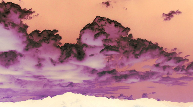
It is official the summer monsoon has arrived and a little early to boot.  The Painted Pony Resort received its' first big rain, 1.27", and as a result the grasslands are greening up nicely.  Of course we had some rain on the evening of the 4th which is traditional.  The image shown below was taken day before the first big rain of the season in June.  With the traditional big monsoon cloud buildup over the Chiricahua Mountains a different kind of presentation was decided upon.  After the usual tweaking of input light levels and contrast the colors were inverted.  This resulted in Portal Peak and the Chiricahua Mountains becoming white, and in silhouette, while the clouds are purple tinged with black and all set in an orange sky.  For those familiar with the area the silhouette of the Chiricahuas should be immediately recognizable and as one local Biologist put it, Happy Biological New Year.

Inverted Color Clouds Over the Chiricahua Mountains
An inverted color image of monsoon clouds over the Chiricahua Mountains.
 
A crepe myrtle in bloom with monsoon showers in the background.

Monday

Cave Creek Canyon: Revealing the Heart of Arizona's Chiricahua Mountains

The first major publication from the Friends of Cave Creek Canyon is back from the publishers and available for purchase.  With 45 chapters, each written by a local expert, the book covers topics including background on the sky islands, geology, all the different types of wildlife, and much much more.  A true labor of love this will be the goto book about the Chiricahua Mountains for the next several decades.  It is available at the Chiricahua Desert Museum or may be ordered from the museum.  It should also be available from Amazon at some point.  There will be a book signing party at the desert museum on Jan 31st from 3-6 PM, where all the authors will be available to sign their chapters for those wishing individualized copies.

friends of cave creek canyon
The new book from the Friends of Cave Creek Canyon

Sunday

Chiricahua Peloncillo Heritage Days 2014

Another great community event this weekend.  The Chiricahua Peloncillo Heritage Days are a yearly event sponsored by local interests to celebrate the natural and cultural heritage of the area.  Starting Friday evening with a reception and keynote address by a climate scientist from Tucson.  Saturday was filled with talks ranging from C.S. Fly to soil mapping in Arizona and New Mexico and a special kids area with activities was hosted by local educators.  Lunch was catered by the Rodeo Tavern with tasty southwestern style chicken fajitas and eggplant casserole.  The rain held off, though we were hoping, and Sundays scheduled walk at Faraway ranch and the wildflower walk up Cave Creek had nice cool temperatures.  This year marked support for the event by Hidalgo county lodgers tax, as well as other local businesses, which means the event is becoming self sustaining.  This bodes well for future Heritage days and I certainly look forward to the event every year.


The craft and farmers market.

Waiting for the talks to begin.

Friends of Cave Creek Canyon display board.

Speakers and presentations.

One More Image from the McCord Tail

Although not the best weather conditions for landscape photography, with some work one image did turn out.  A desaturated view from the overlook on the McCord trail, looking west across Cave Creek Canyon is shown below.  By desaturating the colors the differences in texture create a layered 3D effect with the rock outcrops appearing layered upon one another (click on the photograph to get a larger image).  This creates a diagonal composition with layers of rock outcrops running from the upper left (background layer) down to the lower right (foreground layer).  The layering effect is mirrored by the shadows which also run from the upper right to the lower left.  Notice also how the edges of the rock outcrops are sharp and crisp which lends to the layering effect and enhances the 3D appearance of the image.  All in all, a pleasing image of the landscape.

rock outcrops
A view from the McCord trail above Cave Creek Canyon in the Chiricahua mountains.

Wednesday

One Minute of Cave Creek Canyon

A time lapse spanning several hours compressed into one minute from the Friends of Cave Creek Canyon.  Taken from the mouth of Cave Creek Canyon in the Chirichua mountains just above the Portal Store this iconic view of the canyon is what most people think about when visiting the canyon.


Monday

A Different Monsoon Pattern

This years monsoon pattern seems different.  Monsoon season moisture comes from the south and west with the storms coming from the same direction, but this year the storms are coming from the north and east.  While this pattern is producing good rainfall it is something different.  A 30 year resident commented on the change in the storm pattern but was also pleased with the results. 

Another lightning display was visible over the Chiricahua mountains the other night and below are some images from the storm.  These partially desaturated images of the storm provide a snapshot of the beautiful night time displays residents of the San Simon Valley and visitors to the Painted Pony Resort can expect during monsoon season.


Friday

4th of July Celebrations in Rodeo, New Mexico's Most Western Town

Another 4th of July in Rodeo and as usual, an event to remember.  With only 3 paved roads in the several hundred square miles of the valley, Highway 80 being the only north/south paved road through the valley, it is only logical that the highway is closed every year in the town of Rodeo for the 4th of July celebrations.  The day started early pulling meat that had been slow cooking the previous night preparing for the community dinner, followed by a morning softball game in the park.  The afternoon brought parade preparations and arriving shortly after 5:00 PM the town was already filling.  Cars were rapidly filling up the open areas along both sides of Highway 80 in town.  At 6:00 PM the parade started with horses carrying the flags followed by the parade's grand marshal.  This was followed by floats of every description created by local inhabitants.  Rodeo Radio AM1590 (on the air once a year on the 4th) carried the parade description while floats made their way slowly along the highway.  The theme for this years parade was “anything goes” and was reflected in the variety of floats from a veterans float to unicorns, see images below.  Following the parade everyone gathered inside the Rodeo community center for dinner.  Slow cooked pulled beef with a savory barbeque sauce with beans and coleslaw was the fare, with additional meat being sold to raise funds for the community.  The traditional cake auction followed and then the evenings dance.  Local residents also took advantage of the break in the dry conditions for a fireworks display in the park.  Being the 4th, the traditional start of the monsoon season, I headed back to the Painted Pony Resort early in anticipation of rain.  The drive home was accompanied by a spectacular lightening displays from storms drifting down from the north and upon arrival it started to rain.   PPR picked up 0.96” throughout the night and the desert was alive with activity the next morning.  All the frogs were out calling for mates to take advantage of the ephemeral pools that form during the monsoon creating the next generation of frogs.  Overall it another great event created by the hardworking residents of the bootheel and southeastern Arizona.

4th of july
The parade begins

flag of Rodeo
Rodeo's flag bearer

rodeo new mexico's most western town
Antelope in the parade

Rodeo, New Mexico's most western town
Butterfield stage line

rodeo nm parade
Princess on a unicorn in Rodeo

small town celebrations
Community center dinner

Wednesday

Update: Waterfalls of the Chiricahua Mountains

Locating Cave Creek Falls in the Chiricahua mountains adds another waterfall to the list and the previously published posts on waterfalls.  The waterfalls in Turkey Creek, North Fork, and Cave Creek appear to have year round water making them ideal locations for wildlife viewing, especially in dryer years.  An updated map of waterfalls is provided below showing the relative locations of waterfalls of the Chiricahua mountains.  Presumably there are other waterfalls not yet encountered but the north south line of 8 waterfalls across the interior of the Chiricahua mountains provides days of exploration activity for those interested in visiting permanent water sites in this sky island.  Access to these waterfalls are all off trail (except for the overlook at Winn Falls) and may include some strenuous hiking but the effort in visiting these places is well worth the effort.


waterfall transect
Waterfalls in the Chiricahua mountains

Thursday

In Search of the Fabled Cave Creek Falls, Chiricahua Mountains

In preparing the post on waterfalls of the Chiricahua mountains
it became apparent that a number of waterfalls lie on a north south transect through the Chiricahua mountains.  These include 2 waterfalls in Turkey creek, 2 waterfalls (Shelia falls) in a side canyon of Turkey Creek, North Fork falls (upper and lower), and Winn falls. This brought up an interesting possibility, what about additional waterfalls in other canyons that bisect the waterfall transect?  Exploring Google Earth for possibilities one canyon seemed to be mist shrouded.  Curious I began asking around and no one seemed to know of any other waterfall but single member of the hiking club, he said it was "Cave Creek Falls".  Some what astonished that little was known about the location it prompted a trip.  Starting at Herb Martyr dam and proceeding upstream seemed the easiest way to access this waterfall and several members of the hiking club met up for a reconnaissance trip to try and find the falls.  We were met with flowing water in the upper reaches of Cave Creek (above Herb Marytr dam) and began to follow the water.  The stream bed above the dam is lined with horsetails (Equisetum) and as the 4 hikers and 2 dogs followed the stream bed we encountered a trail.  Thinking there should be a trail to the waterfall we followed it.  Much to our chagrin it was a segment of the Basin trail (segment #247) that leads from Herb Martyr campground to the Snowshed trail that we picked up from the stream.  The trail slowly angled up and away from our intended destination, but after some bushwhacking back in the direction of our goal the falls was spotted in the distance.  Clearly the route to this waterfall stays in the stream bed following the water.  Enlargements of the blurry image indicate that the falls is currently flowing but will be more spectacular during the monsoons or winter rainy season, so a return trip is planned for photographs when more water is flowing.  The total distance walked was 3 miles with 500' of elevation gain.

equisetum
Horsetails along upper Cave Creek

chiricahua mountains waterfall
The Fabled Cave Creek Falls?

day hike
Mountain hikers
Map of the walk upstream from Herb Martyr dam

Friday

South Fork Canyon to Red Rocks and Log Canyon

Ten hikers from the Portal Rodeo Hiking Club met at the Silver Peak Trailhead to sort out vehicles and then drove up South Fork Canyon to trail head.  South Fork canyon was full of birders, with many hanging out near the bridge in South Fork, presumably looking for the Trogons that had been reported. 

The plan was to hike up South Fork canyon to the Burro trail then up to Red Rocks where those wishing more adventure would continue down the trail to a point where it intersects a side canyon (Log Canyon).  Then proceed downstream to the next intersection and head back upstream.  Eight hikers continued past Red Rocks and dropped into Log Canyon while the remaining hikers waited and waved from the ridge top several hundred feet above.  Log Canyon contains several 8-10 ft waterfalls which were dry making the down climbs fairly easy.  These should be quite active during the monsoon season and a return trip would be well worth the minimal effort in accessing the area.  Upon reaching the next intersecting canyon the group headed upstream and within 30 minutes was rewarded with another Chiricahua Mountains waterfall.   Approximately 25-30 ft in height it is clear that a significant amount of water passes over this falls during wetter periods as evidenced by logs jammed against one another and only supported on one end by friction just downstream of the falls.  After finishing a snack the group headed back down the canyon eventually intersecting the trail in South Fork.  The route covered between 4.5 and 5 miles (GPS coverage was lost in Log canyon) and the elevation change was around 900'.  The map for this hike may be found here or in the sidebar.

Illuminated tree above the waterfall


Friction, a 20' log suspended over the creek bed 

Close Friends
A waterfell in Log Canyon

Sunday

Astronomers in Residence

The All-Star Telescope group has been in residence for a week imaging the sky (day and night) from the San Simon Valley. As with all guests a guided hike in the Chiricahua Mountains is offered and the hike chosen for this first group was one of the riparian hikes along Cave Creek which offers spectacular afternoon views of Cathedral Rock and the canyon walls.  The group traveled from the start of the Nature trail just past the Portal Ranger Station and emerging at Sunny Flat campground.  Then back down canyon along the road with a stop at Vista Point.  The afternoon sun illuminated the east wall of the canyon with spectacular views of Cathedral Rock.  The group found a metate along the route and spent some time creating some balancing stone artwork in the stream bed.  Just before heading back to the Painted Pony Resort for dinner the view below presented itself.  A group of upturned faces viewing the southern sky.  It appears the astronomers found themselves captured in stone in Cave Creek Canyon.

Viewing the southern sky


Cathedral Rock from the Nature Trail in Cave Creek Canyon

Tuesday

Leslie Canyon National Wildlife Refuge with the Portal Rodeo Hiking Club

The second stop on last weeks hike with the Portal Rodeo Hiking Club was the Leslie Canyon National Wildlife Refuge.  After a short drive back through Douglas AZ the hiking club headed north to visit another small wildlife refuge at Leslie Canyon in the Swisshelm Mountains southwest of the Chiricahua Mountains.  The refuge is home to endangered fish species as well as a population of Chiricahua Mountain Leopard Frogs.  The American Museum of Natural History Southwest Research Station in Cave Creek Canyon is a partner with Leslie Canyon Wildlife Refuge in the recovery of the Chiricahua Mountain Leopard Frog.  Tadpoles from the population in Leslie Canyon have been reared at the Southwest Research Station in an effort to create a new population within the historic range of the Chiricahua Mountain leopard frog.

The hiking club reassembled at the trailhead on Leslie Canyon Road and proceeded the mile and half north northwest downstream following the old road to the old mine.  Traversing through the high desert scrub the group crossed several contacts between the Naco limestone and granite and rhyolite. Upon reaching the mine the group explored the old mine, viewing the old stone miners building, and examined detritus from early mining activities.  The map for the Leslie Canyon National Wildlife Refuge hike may be found through the link or on the hiking page.

Old stone building in Leslie Canyon

Calcite along the old road in Leslie Canyon National Wildlife Refuge


Casa de Rana at the Southwest Research Station

Friday

Hummingbird Springs

This weeks Portal Rodeo hiking Club hike was a return to Hummingbird Springs on the east flank of the Chiricahua Mountains.  The hike started at Naturalist Journeys outside Portal Arizona with hot juices, tea, and coffee cake before heading off into the Coronado National Forest.  About 2.5 miles into the hike, past Hummingbird Spring, the group divided up with the majority pressing onwards while several hikers headed back to attend to holiday business.  Returning with the other hikers was an opportunity to check out a shelter cave in the quartzite and wander around the old Cienega at the base of hill outside Portal identified on old topographic maps.  Covering only about 5.5 miles while the main group traveled about 8 miles it was another nice day in the forest.  The map showing a trail route is here and in the sidebar.

View from a shelter cave in the Chiricahua Mountains

Wednesday

A Friends of Cave Creek Canyon Video Production

The Friends of Cave Creek Canyon held it's first annual meeting last week (see the annual meeting link for details) at the Chiricahua Desert Museum.  Officers and board members were elected and last years accomplishments were reviewed.  The membership then provided suggestions for projects the friends group could undertake in the following year in cooperation with the Douglas Ranger District of the Coronado National Forest.

Spreading the news about the new Friends of Cave Creek Canyon group requires a multi-prong online approach, one of which is video.  Below is a sample video using the Friends of Cave Creek Canyon logo as an introduction.  A simple series of then and now photographs taken in the Chiricahua Mountains, it demonstrates what can be created to showcase Cave Creek Canyon and the Chirichua Mountains.


Monday

Balancing Stones in the Chiricahua Mountains

The placing of stones to mark special places is a tradition in many cultures including ours.  We place stones at important sites like the Washington Monument at the seat of government and to mark burials .  Historically, standing stones and the megalithic sites are found around the world and the result of many cultural traditions dating back as far as 5000 BCE.  Whether a burial site, astronomical site, or other ceremonial use the common thread through all of these examples of rock placement is the recognition of a special place marked by a piece of the landscape in a manner that is recognizable to other members of the species.  In other words, someone at some time placed a rock(s) to mark, what they considered, a special spot and that location is easily recognizable to later visitors.

The Chiricahua Mountains were known as the "land of standing up rocks" by the Apache Indians who inhabited the area in reference to the unique naturally occurring pillar formations found in the Chiricahua National Monument.  But there are many other special places in the Chiricahua Mountains and the South Fork Zoological and Botanical Area of Cave Creek Canyon is just such place.  This richly diverse riparian area is flanked by high walls of volcanic tuff and is a favorite retreat for many visitors.  In acknowledgement of the uniqueness of South Fork a proof of concept balancing rock project was created.  At several points along the stream bed, where views of the canyon wall are visible, smooth rocks from the stream bed were balanced to recapitulate the view from that location.  At 4 locations balancing rocks were erected starting at the bench on east side of the parking area with one downstream and 2 upstream.  The balancing rock sculptures were comprised to 2 to 5 rocks, and only material within arms reach was utilized.  The works are unobtrusive and may easily be missed by the casual observer to the area.  In addition the works are all transitory, the next high wind or rise in the stream will obliterate all evidence of the balancing rocks and their locations.

These works illistrate several concepts:

First.  A marker of an special place.  A hiker coming around a corner of the trail frequently encounters unexpected views of the canyon in South Fork.  A balancing stone sculpture at these locations highlights these locations and acts as a marker for a special view.  Rather than signage or other methods of permanently marking locations frequently encountered, a sculpture invites the visitor to stop and figure out what is going on and enjoy the view.

Second:  The transitory nature of individuals.  The balanced rocks are not designed to be permanent additions to the landscape but rather something to be viewed, analyzed, and appreciated, then melt back into the landscape with time just like individuals.


Third:  Time. The use of eroded cobbles from the stream bed indicates that while even the mountains are not permanent fixtures of the landscape, in a geological sense, the time scale of change is beyond our capacity to observe.


Vertical panorama of Balancing Stones reproducing the 3 outcrops visible from this location.


Recapitulation of 2 outcrops with the taller on the right.

A single spire reproduced with Balancing Stones

A single balancing stone in the South Fork of  Cave Creek Canyon.